
[SatNews] At the upcoming 31st Space Symposium new products will be launched including this from Airbus Defense and Space.
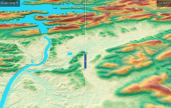
Precise elevation data is the initial foundation of any accurate geospatial product. To date, elevation data users often had to accept a compromise: either DEMs were not available globally / nationwide, or the data did not provide the required accuracy and quality. Airbus Defence and Space (DS)’s WorldDEM can now close this gap (See graphic on right. Left side using WorldDEM and right side using SRTM30) with pole-to-pole coverage coupled with accuracy and quality, that are the defining characteristics of the WorldDEM.
- Vertical accuracy of 2m (relative) / 4m (absolute)
- 12m x 12m raster
- Will be available for the entire landmass of the Earth - 150 Million km2
- Worldwide Elevation Data
WorldDEM is the product of the TanDEM-X Mission (TerraSAR-X add-on for Digital Elevation Measurements), realized as a Public Private Partnership (PPP) between Airbus DS and the German Aerospace Center (DLR). Airbus DS holds the exclusive commercial marketing rights for the data and refines the elevation models according to the needs of commercial users worldwide.
Initially three WorldDEM products will be available:
• WorldDEM
Unedited Digital Surface Model, usually contains radar artifacts and voids
• WorldDEMTM
Edited Digital Surface Model with assured hydrological consistency (i.e. flattening of water bodies, consistent flow of rivers, editing of shoreline)
• WorldDEM DTM
Digital Terrain Model representing the bare Earth terrain (vegetation and man-made objects are removed)
High Level of Detail for Versatile Applications
A multitude of applications such as satellite image orthorectification, military and civil aviation, management of oil and gas fields as well as defence and security related missions, benefit from the unique WorldDEM dataset. The global coverage will also support international cooperation and cross-border mission planning: particularly when the rapid provision of accurate information is of utmost importance (for instance in case of natural disasters), the availability of a standardised, highly accurate DEM will be a major advantage.
Airbus Defence and Space provides WorldDEM sample data sets - for customers to perform a detailed assessment of the suitability of WorldDEM data for varied applications. The sample data also facilitates the testing of the DEM product in the data users’ data management environment.