
[SatNews] Typical activity in recent years includes strombolian activity, lava flow emission and intermittend violent phases of lava fountaining.
INSIVUMEH reported that during 27-28 February gas-and-vapor plumes from Pacaya rose 400-500 m above the crater. Ejected tephra drifted 600 m S and SW. INSIVUMEH and CONRED noted increased activity on 2 March; at 0515 Strombolian activity at Mackenney Crater ejected material as high as 800 m and lava flows descended the W flank. Explosions produced dense ash plumes that rose 2.5 km and drifted 15 km S, SW, and W. Ashfall was reported in El Rodeo (4 km WSW), Patrocinio (about 5 km W), and Francisco de Sales (5 km N). By the next day activity had decreased, but lava flows traveled as far as 1.3 km S. Ejected tephra again drifted 600 m S and SW.
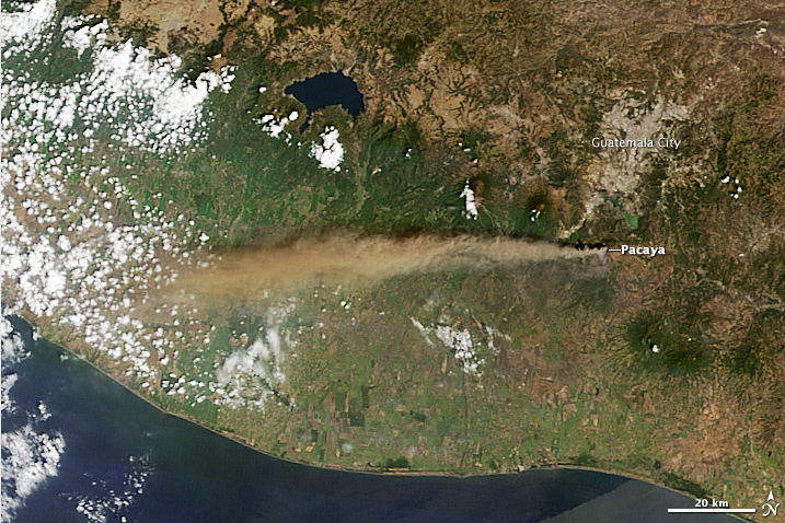
Pacaya Volcano, about 25 kilometers (16 miles) from the center of Guatemala City, erupted on March 2, 2014. This natural-color satellite image was collected on the morning of the eruption by the Moderate Resolution Imaging Spectroradiometer (MODIS) aboard the Terra satellite. NASA image courtesy Jeff Schmaltz LANCE/EOSDIS MODIS Rapid Response Team, GSFC. Caption by Robert Simmon. Instrument: Terra - MODIS
Pacaya volcano near Guatemala City is one of Guatemala's most active volcanoes, and its frequent eruptions are often visible from Guatemala City. Typical activity in recent years includes strombolian activity, lava flow emission and intermittend violent phases of lava fountaining.
Pacaya is a complex basaltic volcano constructed just outside the southern topographic rim of the 14 x 16 km Pleistocene Amatitlán caldera.
A cluster of dacitic lava domes occupies the southern caldera floor. The post-caldera Pacaya massif includes the Cerro Grande lava dome and a younger volcano to the SW. Collapse of Pacaya volcano about 1100 years ago produced a debris-avalanche deposit that extends 25 km onto the Pacific coastal plain and left an arcuate somma rim inside which the modern Pacaya volcano (MacKenney cone) grew.
A subsidiary crater, Cerro Chino, was constructed on the NW somma rim and was last active in the 19th century.
During the past several decades, activity at Pacaya has consisted of frequent strombolian eruptions with intermittent lava flow extrusion that has partially filled in the caldera moat and armored the flanks of MacKenney cone, punctuated by occasional larger explosive eruptions that partially destroy the summit of the cone.
Source: GVP