
[SatNews] ...will compile the global digital 3D map with the highest precision in the world using some 3 million data images...
The Japan Aerospace Exploration Agency (JAXA) will compile the global digital 3D map with the highest precision in the world using some 3 million data images acquired by the Advanced Land Observing Satellite "DAICHI" (ALOS).
The digital 3D map to be compiled this time has the world's best precision of five meters in spatial resolution with five meters height accuracy that enables the company to express land terrain all over the world. Hence its strong character will prove useful in various areas including mapping, damage prediction of a natural disaster, water resource research etc.
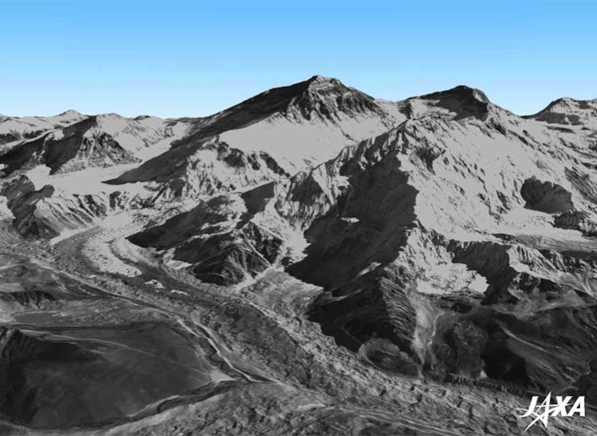
Digital 3D Map Image Example: Mt. Everest
JAXA has been compiling about 100 digital 3D maps per month as part of engineering validation activities of DAICHI. While conducting research and development for full automatic and mass processing map compilations, JAXA now has a perspective to process 150,000 maps per month. By applying research and development results they will start the 3D map compilation in March 2014 to complete the global 3D map in March 2016. JAXA will commission the compiling work and service provision to NTT DATA Corporation.
In order to popularize the utilization of the 3D map data, JAXA will also prepare global digital elevation model (DEM) with lower spatial resolution (of about 30 meters under our current plan) to publish it as soon as it is ready. Its use will be free of charge while anaticipating that data from Japan will become the base map for all global digital 3D maps.