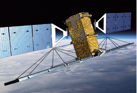
[SatNews] ...its capability makes it an ideal complement to India’s RISAT satellite for disaster management and resource monitoring activities.

MDA’s Information Systems group (MDA) today announced that it has signed a contract with the National Remote Sensing Centre (NRSC) of India to continue to provide RADARSAT information until June 2015. NRSC has been using RADARSAT information since 1998 to support natural disaster and resource management.
 David Belton, the general manager responsible for this business, said "We are pleased to continue our long-term relationship with NRSC, ISRO and the Government of India. RADARSAT-2’s capability makes it an ideal complement to India’s RISAT satellite for disaster management and resource monitoring activities.” Belton further added, “RADARSAT-2’s near real-time information with access to multiple beam modes and coverage options provides timely and actionable information.”
The RADARSAT-2 satellite has global high-resolution surveillance capabilities that include a large collection capacity, high accuracy, and wide-area coverage that is extremely useful in imaging the vast tracts of territory. The satellite acquires data regardless of light or weather condition, provides frequent re-visit imaging options, and is supported by ground receiving stations that provide near real-time information delivery services. This versatility makes RADARSAT-2 a reliable source of information in disaster management and monitoring programs.
RADARSAT-2
MDA has been involved with the RADARSAT satellite program since its inception when it was launched in 1995. It carries a Synthetic Aperture Radar (SAR) instrument capable of imaging the Earth's surface through cloud cover and darkness. The images captured by RADARSAT-1 are sent to Canadian-built ground stations owned by international customers, where the images were processed and modified to provide detailed information about the environment, agriculture, transportation, and defence applications essential to better management of environmental protection, business, and government.
MDA's history at the forefront of SAR technology for spacecraft and aircraft platforms spans more than 30 years. In 1978 MDA was the first company to digitally process a SAR image captured by SEASAT, an advanced American SAR satellite. In 1999 MDA won a contract from the Canadian Space Agency to design, build, and operate RADARSAT-2, the follow-on mission to RADARSAT-1, with enhancements and technical innovations that have advanced the state of radar remote sensing.
MDA operates the satellite and ground segment that includes a Mission Control System, two Telemetry, Tracking, and Control Station Systems, two Canadian Data Receiving Facilities, a Canadian Data Processing Facility, and an associated data archive containing every image the satellite will capture in its operational life. More info is here.
RADARSAT-2's specific mission related features and benefits include the following:
- Finer resolution for improved object detection and recognition
- Range of resolutions, swaths, and incident angles
- Three polarization modes for higher-value data products
- 12-24 hours programming lead time for routine acquisition
- 4-12 hours lead time for emergency acquisition
- Near-real time processing and product delivery

