
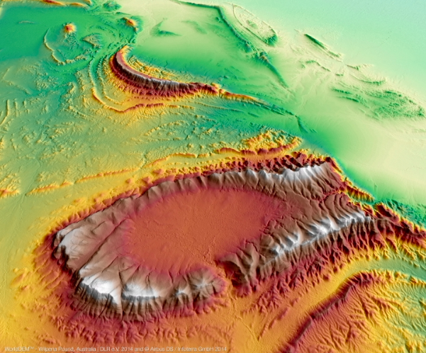
WorldDEM™ Digital Surface Model - Wilpena Pound, Australien
Double the lifespan is something we'd all like to achieve and celebrate providing we are enjoying good health as well, and that's just what Airbus's TerraSAR-X has achieved with 10 years of flawless operations in orbit providing high-resolution radar images in all weather conditions 24 hours a day. Good job considering it was designed to operate for five years.
Developed and constructed by Airbus Defence and Space teams from Friedrichshafen for the German Aerospace Center (DLR), the satellite orbits at a height of 514 km or 319.38 miles and provides radar imagery to a wide variety of scientific and commercial users.
Eckard Settelmeyer, Head of Earth Observation, Navigation and Science at Airbus in Germany said that TerraSAR-X has not only achieved double its service life, having orbited the Earth 55,459 times and traveled 2.4 billion kilometers, all while boasting 99.9 percent availability, it has also delivered an outstanding performance. Further, TerraSAR-X is in such a good condition that a current assessment indicates it can be operated for a few more years in space until a follow-on system is in place.
François Lombard, Head of the Intelligence Business Cluster at Airbus Defence and Space added that TerraSAR-X features a unique geometric accuracy. With six imaging modes, it offers flexible coverage and resolutions ranging from 0.25m to 40m, and answers the needs of a wide range of domains, like engineering companies to ensure the safe operation of large construction projects, oil and gas enterprises to monitor their production, or Intelligence and Security agencies for targeted surveillance and detailed change detection.
Since the launch of its almost identical twin TanDEM-X in 2010, both satellites have been flying in formation with the distance between them only a few hundred meters. They have acquired a huge amount of data that provides the basis for the new standard of global elevation models, WorldDEM, covering the entire Earth’s.
TerraSAR-X and TanDEM-X offer high acquisition frequency, regardless of area of interest or weather conditions, which is crucial for natural or man-made disasters, where reactive mapping is needed to support rescue planning.
Following the launch of the PAZ satellite at the end of this year on the same orbit, the three satellites will be operated in a constellation to deliver even more optimized revisit time, increased coverage and improved services.
Airbus Defence and Space is working on the next generation of Synthetic Aperture Radar (SAR) satellites as a follow-on mission to TerraSAR-X and TanDEM-X from 2022.
The TerraSAR-X image gallery is available here.