

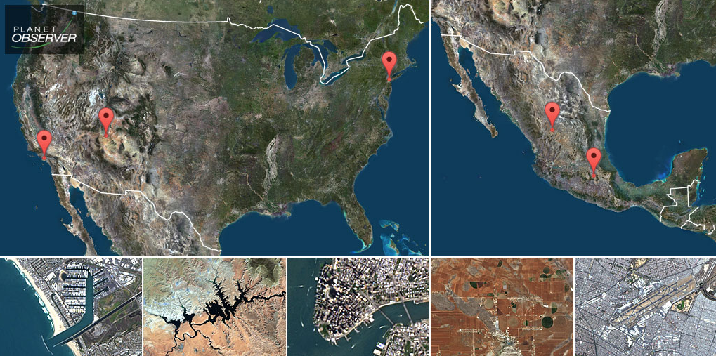
A new basemap that covers more than 10 million square kilometers at 15-meter resolution is debuted by PlanetObserver. PlanetSAT Updates is a basemap of the United States and Mexico.
The French company PlanetObserver, specializing in geospatial data production, has just finalized the new PlanetSAT Updates imagery basemap of the United States and Mexico. Processed with fresh and cloudless Landsat 8 source data, this new basemap covers more than 10 million square kilometers at 15-meter resolution. With an advanced natural color imagery processing, this mapping product provides up-to-date and detailed geographic information, perfect for 1:50,000 scale mapping.
Key user benefits of the new PlanetSAT Updates basemap are:
- Up-to-date and reliable geographic information data, available immediately
- Plug-and-play product, ready-to-use in all professional applications
- Flexible licensing and pricing models
PlanetSAT Updates basemap is a backdrop solution that brings added value to many commercial and military applications, ranging from flight simulation, geo-intelligence and mission preparation solutions, geographic information systems, to mapping applications such as web-based mapping solutions.
The production of PlanetSAT Updates basemap of the United States and Mexico is part of a comprehensive annual maintenance program set up by PlanetObserver in 2016. All new PlanetSAT Updates productions are merged into PlanetSAT Global imagery basemap. Users benefit from constantly refreshed data, convenient when developing new applications and creating efficient services serving a wide variety of markets.
Laurent Masselot, CEO of PlanetObserver said that the new PlanetSAT Updates basemap of the United States and Mexico fulfills customers’ expectations, specifically for those based in North America, a market that they target in partnership with East View Geospatial. Masselot is excited to offer an efficient and unique mapping product with advanced color balance that will improve user experience.
PlanetObserver offers a full range of value-added geospatial products: PlanetSAT range of global imagery basemaps, PlanetDEM global and accurate Digital Elevation Models, and on-demand service for Very High Resolution imagery and orthophotography. All products are developed internally, by PlanetObserver's expertise in geospatial data processing and 30 years of technological expertise. PlanetObserver geospatial data are perfect for numerous commercial, military and consumer applications, ranging from web-mapping to 2D and 3D visualization and simulation solutions, GIS tools, cartographic mapping to audio-visual production.