Japan's lunar orbiter Kaguya yesterday concluded its successful scientific mission with a controlled impact on the lunar surface.
The impact occurred at 16:25 UT (18:25 GMT) on the Moon's near side, close to the limb, at lunar coordinates ~80.4°E and ~65.5°S. The location and time made the impact visible from Earth's southern hemisphere, and one early result has already been reported from the
AAT telescope in Australia.
The impact marked the end of more than 18 months of operations in lunar orbit.
Kaguya was launched on 14 September 2007 and upon arrival at the Moon entered a circular polar orbit with an altitude of ~100 km. Earlier this year, the orbit's altitude was lowered to perform observations at higher spatial resolution. Now, at the end of its available fuel and with a 2-tonne dry mass, the spacecraft has been sent spiralling down to the lunar surface. The Kaguya spacecraft touched down on Wednesday June 10th at 18:25:13 GMT at the time planned by the project after a final orbit maneuver about one hour earlier. Dropping from an altitude of 7 km, the probe was just 1 km above the ground 1 minute before landing, as shown by the Kaguya altimetry data.
Europe's first lunar probe,
ESA's
SMART-1, also concluded its mission with a controlled impact on the Moon. SMART-1 impacted the lunar surface on September 3, 2006, having orbited the Moon since it was caught in its gravitational field in November 2004. The event was observed with ground-based telescopes and the flash from the impact was detected at infrared wavelengths.
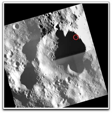
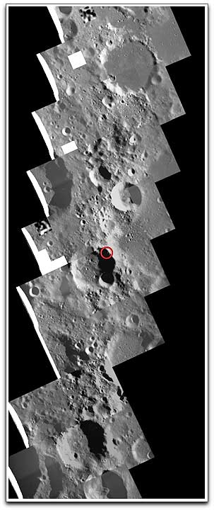
Using survey images obtained by the SMART-1 AMIE camera, the ESA SMART-1 team has constructed a mosaic map of the area on the lunar surface along the ground trace of Kaguya's final orbit. The point of impact (80.4°E, 65.5°S based on the latest data released by JAXA, the Japan Aerospace Exploration Agency) is indicated with the red circle. North on the Moon is up in this view and the map is ~10° wide. The large crater that is partly visible at the edge of the mosaic, just above and to the left of the impact point, is crater Gill with a ~66 km diameter. The SMART-1 map shows that Kaguya's impact site lies within a much cratered ancient highland terrain. This meant that as the spacecraft sheared over the lunar surface around the points of closest approach (perilune) during its final orbits, the high topographic relief of the terrain played a role in where the exact final impact site would be. The incidence angle upon impact, determined by the spacecraft orbit and also the local slope of the lunar surface, affected the impact flash and the dynamics of the ejecta.
Observing conditions and early results
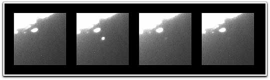
Although the phase of the Moon was gibbous, less than four days after Full Moon, the impact site was on the night side of the terminator and therefore was not directly illuminated by the Sun. This allowed ground-based telescopes to look for any emission caused by the impact. Observers at the
Anglo-Australian Telescope (AAT) in Australia performed dedicated observations following a request of ESA scientists, and have successfully detected the Kaguya impact as a bright flash. The observations with the 4-metre telescope were done in the near-infrared at 2.3 µm. After the event, the lunar surface at the site of impact now is a welcome subject for observations by future Moon orbiting missions that could obtain data of the area to compare it with pre-impact data, for example with the SMART-1 maps.
Kaguya (also called
SELENE, for
SELenological and ENgineering Explorer) was launched by the
H-IIA Launch Vehicle on September 14, 2007, at 10:31:01 a.m. JST (01:31:01 UT), from the
Tanegashima Space Center in Japan. Upon arrival at the Moon, the orbiter released two smaller satellites in separate elliptical polar orbits:
OKINA (a relay satellite for communications) and
OUNA (a VLBI radio source satellite for supporting radio measurements).
Topical Tags :
Regional Tags :
