
This company just expanded its nautical chart offerings in an agreement with the South African Navy Hydrographic Office (SANHO).
South Type Nautical Charts Series Description Bathymetry at contour intervals as small as 5 meters with spot depths in meters; shallow coastal water in darker shade of blue; breakers, wrecks, submerged and awash rocks and reefs, obstructions, submarine cables, pipelines, and islands shown; both large and small scale charts in the series show shoreline characteristics (sandy, rocky, cliffs). Larger scale charts show more detailed information such as harbor features (piers, wharfs, jetties), and aids to navigation (buoys, beacons, lighthouses). Magnetic variation provided.
The company, East View Geospatial's (EVG) agreement makes EVG an official distributor of SANHO’s original paper charts — the only paper distributor located within the USA.
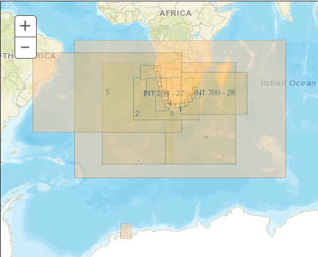
The South Africa nautical chart series includes 91 charts and covers all of South Africa, as well as the coastlines of select neighboring countries. For full coverage information and a sheet index, please visit .
EVG is the only authorized distributor of original paper SANHO charts in the USA. The agreement with SANHO allows EVG to offer original paper charts direct from the publisher, ensuring that customers receive the most up-to-date edition of charts from this series.
With this latest agreement, East View Geospatial continues its mission to provide customers with the most authoritative and up-to-date geospatial data from across the globe. For more information on nautical charts series offered by EVG.
East View is comprised of East View Information Services, East View Geospatial and East View Map Link. East View maintains thousands of supplier/publisher relationships throughout the world for maps and geospatial data and Russian, Arabic and Chinese-produced social and hard science content.