


[SatNews] To assist in the disaster response efforts, Caltech and JPL scientists have constructed a preliminary picture of what happened below Earth's surface during the recent 7.8-magnitude Gorkha earthquake in Nepal, using a combination of satellite radar imaging data, GPS data measured in and near Nepal, and seismic observations from instruments around the world.
The team's observations and models, produced through the Advanced Rapid Imaging and Analysis (ARIA) project–a collaboration between Caltech and JPL, —include preliminary estimates of the slippage of the fault beneath Earth's surface. The fault movement was responsible for the generating the April 25, 2015, earthquake that has killed and injured thousands. In addition, the scientists ARIA scientists have provided first responders and key officials in Nepal with information and maps that show block-by-block building devastation, as well as measurements of ground movement at individual locations around the country.
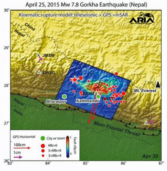
The modeled slip on the fault is shown as viewed from above and indicated by the colors and contours within the rectangle. The peak slip in the fault exceeds 19.7 feet (6 meters). The ground motion measured with GPS is shown by the red and purple arrows and was used to develop the fault slip model. Aftershocks are indicated by red dots. Background color and shaded relief reflect regional variations in topography. The barbed lines show where the main fault reaches Earth's surface.
Imageccredit: NASA/JPL-Caltech.
"As the number of orbiting imaging radar and optical satellites that form the international constellation increases, the expected amount of time it takes to acquire an image of an impacted area will decrease, allowing for products such as those we have made for Nepal to become more commonly and rapidly available," said Mark Simons, professor of geophysics at Caltech and a member of the ARIA team. "I fully expect that, within five years, this kind of information will be available within hours of big disasters, ultimately resulting in an ability to save more lives after a disaster and to make assessment and response more efficient in both developed and developing nations."
Over the last five years, Simons and his colleagues in Caltech's Seismological Laboratory and at JPL have been developing the approaches, infrastructure, and technology to rapidly and automatically use satellite-based observations to measure the movement of Earth's surface associated with earthquakes, volcanoes, landslides and other geophysical processes.
"ARIA is ultimately aimed at providing tools and data— for use by group ranging from first responders, to government agencies, and individual scientists—that can help improve situational awareness, response and recovery after many natural disasters," Simons says. "The same products also provide key observational constraints on our physical understanding of the underlying processes such as the basic physics controlling seismogenic behavior of major faults."
ARIA is funded through a combination of support from JPL, Caltech and NASA.