
[SatNews] "...look forward to further enhancing this relationship by contributing to Thailand’s national objectives in resources management and disaster mitigation.”
MDA’s Information Systems group (MDA) announced today that it has renewed its contract with the Geo-Informatics and Space Technology Development Agency (GISTDA) to continue to downlink of RADARSAT-2 data that will be used to support critical infrastructure serving Thailand’s various resources management and disaster mitigation applications. GISTDA has been receiving and processing RADARSAT satellites data imagery to support various applications since 2000.
RADARSAT-2's specific mission related features and benefits include the following: Finer resolution for improved object detection and recognition; Range of resolutions, swaths, and incident angles; Three polarization modes for higher-value data products;12-24 hours programming lead time for routine acquisition; 4-12 hours lead time for emergency acquisition; Near-real time processing and product delivery
David Belton, the general manager responsible for this business, said “We greatly value our long-term partnership with GISTDA and look forward to further enhancing this relationship by contributing to Thailand’s national objectives in resources management and disaster mitigation.”
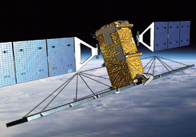
The RADARSAT-2 satellite has global high-resolution surveillance capabilities that include a large collection capacity, high accuracy, and wide-area coverage that is extremely useful in imaging the vast tracts of territory. The satellite acquires data regardless of light or weather condition, provides frequent re-visit imaging options, and is supported by ground receiving stations that provide near real-time information delivery services. This versatility makes RADARSAT-2 a reliable source of information for resource and disaster management programs.
MDA operates the satellite and ground segment that includes a Mission Control System, two Telemetry, Tracking, and Control Station Systems, two Canadian Data Receiving Facilities, a Canadian Data Processing Facility, and an associated data archive containing every image the satellite will capture in its operational life. Learn more here.