
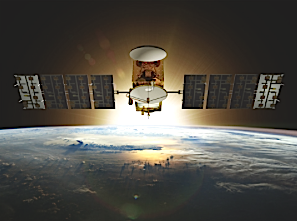
Artist rendition of the Jason-3 satellite. Image Credit: CNES/ill./DUCROS David, 2013
[SatNews] Jason-3 is the newest satellite in a series designed to maintain long-term satellite altimetry observations of global sea surface height. These data provide critical ocean information that forecasters need to predict devastating hurricanes and severe weather before they arrive onshore. Jason-3’s highly accurate altimetry measurements will be used for a variety of scientific, commercial and operational applications, including:
- Hurricane intensity forecasting
- Surface wave forecasting for offshore operators
- Forecasting tides and currents for commercial shipping and ship routing
- Coastal forecasting for response to environmental problems like oil spills and harmful algal blooms
- Coastal modeling crucial for marine mammal and coral reef research
- El Niño and La Niña forecasting
Over the long term, Jason-3 will help to track long-term global sea level rise, an increasing threat to the resilience of coastal communities and to the health of our environment.
Jason-3 would not have been possible without a global partnership between Centre National d'Etudes Spatiales (CNES), European Organisation for the Exploitation of Meteorological Satellites (EUMETSAT), and the National Aeronautics and Space Administration (NASA), that freely shared scientific knowledge, financial support and a vision for the betterment of the global community.