
The third annual update of the satellite map of the state of Queensland, Australia by the New Space pioneer Earth-i has been completed and the colors are amazing.
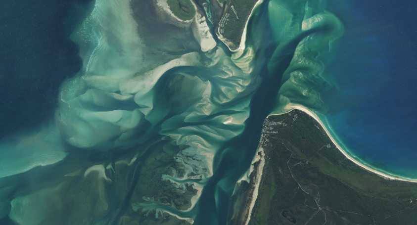
The map covers the whole of Queensland’s 1.9 million km2 and was created by Earth-i for the Department of Natural Resources, Mines and Energy (DNRME). The first map was produced in 2016 with Earth-i reappointed for updates in both 2017 and 2018. Earth-i faced strong competition to lead this prestigious project which has set the standard for Governments across the world who are looking to use images of Earth taken from space to improve their decision-making.
Around 6,000 very high-resolution images from the DMC3 Constellation were used for the 2018 update of the map with multiple re-visits to tropical areas with heavy cloud cover. The images have a pixel size of 80cm (one pixel equates to 80cm on the ground) so that details such as individual trees can be easily seen.

All three maps are available on an online portal - ‘The Queensland Globe’- where images can be viewed and printed.
These images are used by a variety of Government departments, local agencies and natural resource management groups to manage and monitor Queensland’s resources and improve policy development, investment and planning decisions. The map also helps to monitor environmental changes, and helps with the planning of long-term land development strategies.

Steve Jacoby, Executive Director of Land and Spatial Information at the Queensland Department of Natural Resources, Mines and Energy, said that Earth-i is an innovative company that combines quality images and analysis with excellent service. The Queensland Globe is very well used and helping to improve the decision making of a wide variety of organizations.
Paul Majmader, Commercial Director of Earth-i, said that winning this contract for the third consecutive time is a tribute to their entire team. The DNRME in Queensland is showing Governments around the world how important regularly updated, high resolution data is in making informed policy decisions.
As qualified suppliers to other states in Australia, Earth-i is helping Australia retain its position as a leader in the development of geospatial data infrastructure which is driving both economic development and good environmental management.
Earth-i currently provides satellite imagery, data analysis and insights services from a range of Earth Observation (EO) satellites, including the DMC3, SuperView, KOMPSAT and Planet constellations of satellites. Earth-i launched its own satellite service demonstrator satellite, VividX2, in January 2018.
The upcoming launch of its own satellite constellation, Vivid-i, is an evolution of Earth-i’s existing image and EO analytics business. The Vivid-i Constellation will enable Earth-i to meet the growing demand for high-resolution EO data, analytics and insights, while delivering pioneering high-frame rates, ultra-high-definition color video, and very high frequency revisits.
The company is pioneering the application of machine learning and AI solutions to Earth Observation data to provide deeper insights in support of critical business decisions and policy formulation. Earth-i has a wide range of clients globally including National and Local Governments and a multitude of specialist geospatial companies and other commercial organisations.
Earth-i is headquartered in Surrey, UK, on Europe’s largest academic space campus near to many other UK space-related companies including Surrey Satellite Technology Ltd. (SSTL).