
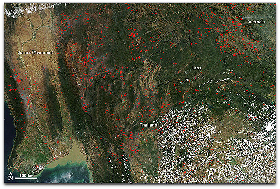
NASA image courtesy the MODIS Rapid Response Team. Caption by Rebecca Lindsey.
In the first months of the year, it is not uncommon for satellites to capture sights such as the one shown in this image: hundreds of active fires burning across the hills and valleys of Burma (Myanmar), Thailand, Laos, and Vietnam. This photo-like image was captured by the Moderate Resolution Imaging Spectroradiometer (MODIS) on NASA’s Aqua satellite on February 10, 2010. MODIS detects fires from thermal infrared energy radiating from the surface, not smoke plumes. The heat energy is invisible in images like this, but the locations where MODIS detected fires are labeled with red dots.
In permanently cultivated (usually lowland) areas, fires are used to burn crop residues and get the land ready for the upcoming growing season. In urban and residential areas, people burn leaves, trash, and brush. In the mountains, fires may indicate permanent conversion of forest to agricultural land, or they may be associated with shifting cultivation, also known as swidden farming. In this system, patches of forest are cyclically felled, burned, cultivated, and then fallowed for a time. Secondary forest or other vegetation reclaims the clearing during the fallow period. The fires in this region have been part of the land management practices for hundreds, possibly thousands of years, and they are not necessarily immediately hazardous. But they nevertheless have a big influence on air quality and human health, greenhouse gas emissions and the Earth’s carbon cycle, and biodiversity.