 [SatNews] Reactor heat detection may be possible from aloft...
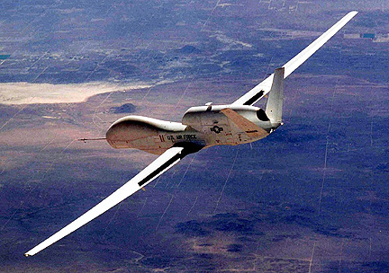
A U.S. Air Force Global Hawk UAV based out of Guam is tentatively scheduled to overfly the damaged reactors at the Fukushima Dai-1 nuclear plant in order to provide a more complete picture of what's going on inside the facility. Japan has been battling a third potential catastrophe in the form of a nuclear meltdown. Dangerous levels of radiation are preventing nuclear workers and emergency responders from safely approaching the facility's four reactors to control fires and assess the extent of damages. If the Global Hawk can provide detailed images of the buildings, it could be a big help for the authorities planning the next attempts to cool down the damaged reactors.
The Global Hawk is an autonomous, jet-powered UAV with a sensor package that includes synthetic-aperture radar as well as electro-optical and infrared sensors with telescopic capability for high-resolution imagery. The infrared sensors, which can detect heat, may be able to acquire images of the reactors showing which parts of them are at what temperatures, and repeated observations could provide critical data about the effectiveness of different attempts at cooling the reactor vessels and spent fuel pools.
Helicopters have already dumped approximately 30 tons of seawater on the No. 3 reactor building to attempt to cool it down, but officials are still trying to determine if such had any effect. Data from the Global Hawk's sensors could potentially detect whether or not the seawater had an effect on the temperature inside the reactor, and therefore whether or not additional helicopter flights, or deploying truck-mounted water cannons, makes sense. For the past few days, the Global Hawk has been assisting with disaster relief efforts around Japan by collecting near real-time imagery which allows officials to better prioritize and direct their resources. This is a familiar role for the Global Hawk, which also helped to monitor the situation in Haiti after the 7.0 earthquake there in January of last year.
The Global Hawk, with a 35-meter wingspan, is capable of conducting surveillance for 36 hours at a stretch at altitudes of up to 18 kilometers (60,000 feet). It can survey 100,000 square kilometers (about 40,000 square miles) of terrain — the size of the state of Illinois — in a single day, entirely without human intervention: Once the robot receives its instructions, everything from taxiing to takeoff to data collection to landing is performed entirely autonomously. The drone was originally designed for the U.S. Air Force as a long-duration surveillance aircraft, and has a history of successful and effective use in Iraq and Afghanistan, offering on-demand near real-time imagery that can't be provided by satellites. The platform proved to be successful enough that Global Hawks have been adapted for climate monitoring and environmental mapping, and NASA has a pair of the UAVs that it's using as technology demonstrators. (Source: IEEE Spectrum).

