
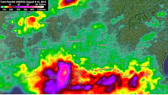
NASA's IMERG data from August 8 to August 15, 2016 showed over 20 inches (508 mm) of rainfall was estimated in large areas of southeastern Louisiana and extreme southern Mississippi. Even greater rainfall totals of 30 inches (762 mm) were indicated in a small area of Louisiana west of Lake Pontchartrain. Credits: NASA/JAXA, Hal Pierce
Feast or famine—flood or drought—sometimes it seems as though nature only works in the extremes. And despite the sophisticated satellites and information and studies conducted by educated meteorologists, all that they can do is report the weather—not control it.
An extremely severe rainfall event hit the states of Louisiana and southern Mississippi when a very slow moving low pressure system continuously pulled tropical moisture from the Gulf of Mexico.
Measurements by the Global Precipitation Measurement or GPM mission core observatory satellite showed that rainfall intensity within the low pressure system actually increased on August12 as the low pressure area bringing the rainfall settled over southeastern Louisiana. GPM is a joint mission between NASA and the Japan Aerospace Exploration Agency JAXA.
At least four people have died in record flooding after the unusually heavy rainfall starting falling the week of August 8. More than 27 inches (686 millimeters (mm)) of rain have been reported in the area. This is the second time this year that record flooding rainfall has hit Louisiana. At least 27 inches (686 mm) of precipitation was also reported in Louisiana during the middle of March 2016 and also caused record flooding.
At NASA's Goddard Space Flight Center in Greenbelt, Maryland, NASA's Integrated Multi-satellite Retrievals for GPM (IMERG) data were used to make estimates of total rainfall over the northern Gulf of Mexico during the period from August 8 to August 15, 2016.
The Integrated Multi-satellitE Retrievals for GPM (IMERG) IMERG data showed heavy rainfall totals moving toward the northwest from the Florida Panhandle into the central northern Gulf coast. Over 20 inches (508 mm) of rainfall was estimated in large areas of southeastern Louisiana and extreme southern Mississippi. Even greater rainfall totals of 30 inches (762 mm) were indicated in a small area of Louisiana west of Lake Pontchartrain.
Heavy rainfall and flooding is now predicted to occur northward into the Mississippi valley as tropical moisture continues to be transported northward and interacts with a nearly stationary frontal system. Heavy rainfall has also recently affected southeastern Texas and western Louisiana.
The National Weather Service (NWS) in New Orleans, Louisiana noted in a forecast discussion on August 15, "As historical and devastating river flooding continues over areas between Baton Rouge and Lake Maurepas, the weather has returned to a more typical summer pattern with isolated to scattered showers and thunderstorms developing with daytime heating."
NWS also noted that several of the rivers in and around the greater Baton Rouge area still remain at high levels after peaking at record or major crests. NWS noted that several points downstream and close to Lake Maurepas still have a way to go before broad cresting. NWS New Orleans cautioned that some locations will also undergo backwater flooding well away from the main streams, so this event remains in full swing.
Hal Pierce / Rob Gutro
NASA's Goddard Space Flight Center