
The data from one of the instruments on NASA's Terra satellite provide observations of Africa's surface and atmosphere, including vegetation structure, airborne pollution particles, cloud heights and winds. Transfer of these data to a distribution center in Africa will make it broadly accessible to African users who have not been able to remotely download the large data files because of limitations in the continent's Internet infrastructure. The data are from the Multi-angle Imaging SpectroRadiometer (MISR) on Terra. NASA's Jet Propulsion Laboratory in Pasadena, Calif., built and manages the instrument, and NASA's Langley Research Center in Hampton, Va., processes, archives and distributes the data.
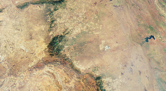
Downward-looking camera view of the area around Kruger National Park in northeastern South Africa, acquired Aug. 18, 2010, by the MISR instrument on NASA’s Terra spacecraft. The imaged area is 380 kilometers (236 miles) wide. The bright white feature above and to the right of image center is the Palabora Copper Mine, and the water body near upper right is Lake Massingir in Mozambique. Kruger National Park lies between these landmarks and stretches from north to south for some 350 kilometers (217 miles). Image credit: NASA/GSFC/LaRC/JPL, MISR Team
MISR has been making continuous measurements of Earth's surface and atmosphere for more than a decade. MISR observes the sunlit portion of Earth continuously, viewing the entire globe between 82 degrees north and 82 degrees south latitude every nine days. Instead of viewing Earth from a single perspective, the instrument collects images from nine widely spaced view angles. South Africa's Council for Scientific and Industrial Research (CSIR) in Pretoria will distribute the data at no charge to the research community in the region. CSIR will facilitate access to the large volume of MISR data as part of its broad strategy of educating, training and transferring knowledge to the southern African research community. NASA shipped most of the data on high-density tapes this summer. The agencies will ensure the database stays updated with current MISR observations by upgrading connectivity and facilitating sharing of data among participating academic and research institutions.