
Forget the moon. Forget Mars, too. While China, India, Russia and the United States jostle for an interplanetary edge, an intensifying space race is underway in the outer reaches of the earth's atmosphere where energy companies are seeking to gain a competitive advantage in the Permian Basin.
At least a half dozen energy data firms are offering satellite imaging of the 75,000-square mile oil field to provide intelligence to energy companies on the activities ranging from the appearance of drilling pads and hydraulic fracturing ponds to the movements of drilling rigs and frac crews across Permian's expanse in West Texas and southeastern New Mexico.
Some data companies have launched their own satellites to monitor the Permian while others buy images from NASA, the European Space Agency and commercial operators. Each of the data companies are trying to set themselves apart by how they process those images and the market intelligence that they derive.
That intelligence can be vital in a notoriously secretive industry. In the increasingly crowded Permian, where companies are drilling into the same geologic formations in close proximity, oil and gas producers want to know where competitors are operating to making sure their horizontal drilling, which can cross the shale play underground for miles, doesn't interfere with the operations of other companies. For oilfield services companies, the intelligence provides business leads on which drilling sites and producers will need equipment and crews.
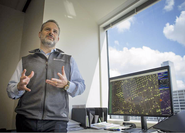
Sourcewater CEO Josh Adler talks about the next steps his company will be taking using satellite imagery at the company's office in downtown Houston, Tuesday, Aug. 13, 2019. The Houston-based company has developed software and artificial intelligence technology that uses satellite images to track oil field activity in the Permian Basin of Photo: Mark Mulligan, Houston Chronicle / Staff photographer
Environmental groups, meanwhile, are using satellite images to track pollution and the flaring, or burning off, of natural gas in oil fields across the United States. One of those environmental groups plans to launch a satellite of its own in 2021 to track global emissions of methane, the primary component of natural gas and a potent greenhouse gas.
Energy data firms have used satellites for years to gauge storage tank volumes and track the movements of tankers in the world's oceans, but using them to monitor onshore exploration and production activity in shale plays is new. The first satellite services to monitor shale activity appeared just two years ago.
Satellite images paired with analysis can provide more detailed information at a much lower cost and more safely than planes, drones or teams of people driving along rural roadways, the data services companies said.
"You would need a team of over 100 people working 24 hours a day, seven days a week to do the same thing our patented artificial intelligence does in less than one hour — scan the entire Permian Basin to spot every new well pad and frac pond every five days," said Josh Adler, CEO of the Houston oilfield data company Sourcewater.
Satellite Tech
Launched in 2014, Sourcewater began as an online platform for landowners, drilling rig operators, hydraulic fracturing companies and disposal well operators to buy, sell or move freshwater and wastewater in the oilfield. Since drilling for freshwater and building frac ponds often does not require permits, tracking that type of activity was difficult and labor intensive.
"In the early days, we would drive around, see a roadside sign by a frac pond for somebody selling water and call the number," Adler said. "The landowner was always thrilled to hear that they could sell their water on the internet — so the question became how could we find all these people?"
Satellite images released every five days by NASA, the European Space Agency and other sources provided the answers. Sourcewater engineers developed an artificial intelligence program that looks for new drilling pads and frac ponds, which appear as either white or blue-green squares in the desert landscape.
Drilling pads and frac ponds appear months ahead of drilling permit filings, making them reliable predictors of future exploration and production activity, Adler said. Many times, he said, rigs are already in place before drilling permits are published while hydraulic fracturing crews finish their work weeks, months or sometimes even a year before reports are released by regulators.
"Everybody who is selling anything in the Permian Basin — whether it's Halliburton or Schlumberger or a pipeline company or a construction service or a water hauling company — everybody — wants to know who will be drilling where and when," Adler said. "We can now do that months ahead of permits."
Space Race
Adler and Sourcewater are not alone. At least five other companies are using satellites to monitor exploration and production activity. Most chose to debut their services in the Permian Basin, one of the largest, busiest and most productive oil fields in the world. The fierce competition in Permian among oil majors, large independents and smaller production companies make the data gleaned from satellite images all the more valuable.
The San Francisco satellite company Planet, founded by three former NASA scientists, has nearly 150 of its own satellites in orbit. The company began monitoring drilling and hydraulic fracturing activity in the Permian Basin in April 2018.
The Scottish data firm Westwood Global Energy Group bought Houston oilfield analytics firm Energent Group Software in a 2017 deal that set the stage for another satellite service, which the company launched in the Permian Basin in October.
French energy data firm Kayrros has used satellite images to monitor petroleum storage tanks since May 2017. In July, Karryos began analyzing satellite images to provide intelligence on hydraulic fracturing activity in the Permian, which it says is under-reported.
Airbus, the European aerospace giant, is signing up users for a satellite service to monitor the West Texas shale play while the energy arm of the New York consulting firm McKinsey & Co. launched its new Permian Basin satellite service on July 30. Using satellite images purchased from commercial satellite operators, McKinsey’s service divides the life of an oil well into four stages — pad clearing, drilling, fracking and production — allowing customers to closely monitor a site’s progress.
But that's just the first step for the company. Berend Heringa, a partner with McKinsey's Energy Insights practice in London, told the Houston Chronicle that the firm has even greater ambitions outside of the Permian Basin.
"We have also recently developed a monitoring capability for refineries in the Mediterranean, the Middle East and the Far East, coupled with a pipeline of other data sets we would like to create leveraging images from space," Heringa said. "Earth observation using advanced analytics will rapidly grow in the coming years and we want to be at the forefront."
Counting DUCs
An important service that some satellite companies provide in the oil patch is a more accurate inventory of drilled but uncompleted wells. Known as DUCs, the wells were drilled to satisfy lease obligations. but not put into production because oil prices were too low to make money.
For exploration and production companies, DUCs can offer companies a glimpse into a competitor’s activity. And with crude oil prices stubbornly stuck in the $50 -to $60 per barrel range, they also offer insight into a competitor’s break-even price and their inventory of ready-to-go wells when market conditions improve.
Services companies, on the other hand, view DUCs as leads for future work and use the information to bid on contracts from cranes and power generators to sand, water, and chemicals to fracking services. Using DUCs to judge how much work is out there, service companies can set prices and estimate future revenue.
“It’s particularly valuable on the company-by-company level,” Kayrros Product Manager Oliver Zhu said about DUCs. “We know not only where the wells are but who’s the operator. If you’re tracking an individual company, it’s very critical information to have.”
More than 8,000 DUCs dot shale plays across the United States, with nearly half of them in the Permian Basin, the Energy Department estimated. But based on and analysis of satellite images, Karryos put the number of DUCs in the Permian Basin closer to 1,400 — meaning much less work might be out there for service companies.
Environmentalists
Oil are gas companies are not only ones using satellites to track activity in shale plays. Environmentalists are using the technology to track methane emissions and other forms of pollution.
The Environmental Defense Fund, a national advocacy group, plans to launch its own satellite into orbit in 2021. Dubbed MethaneSAT, the satellite will monitor methane emissions around the world and make the data public allowing everyday people, scientists, environmentalists and policy makers to get a first-hand glimpse at how pollution affects the planet.
In an April 2018 speech announcing plans to launch the satellite, Environmental Defense Fund President Fred Kupp said the goal of MethaneSAT is to turn data into action.
“Citizens will be powered to take action, governments will tighten the regulations and because all of our data will be free and public, there will be transparency,” Krupp said. “We’ll all be able to see how much progress is being made and where”