
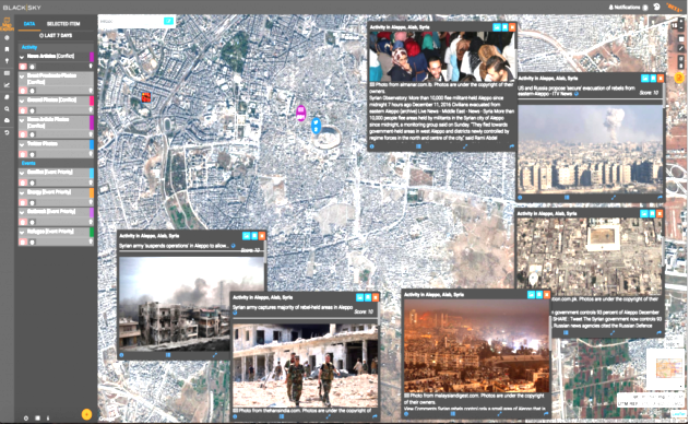
BlackSky’s online imaging platform can link a satellite view of the embattled Syrian city of Aleppo to real-time social media streams about the area to provide greater context. (Spaceflight Industries Graphic)
Folks got a sneak peek at images from Spaceflight, revealing Earth observation images of some areas of great social unrest.
Seattle-based Spaceflight Industries provided a glimpse of information online using their BlackSky satellite imagery platform. The concept is to provide overhead views of sites around the world with social-media posts and other reports about what’s shown in the pictures, most recently the alarming posts from the humanitarian crisis in the Syrian city of Aleppo where tens of thousands of civilians have been caught in devastating bombing attacks and house-to-house fighting.
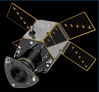
Deimos 2 [Satrec Initiative]
The BlackSky platform provides access to imagery from more than 10 Earth-watching satellites, including Korea’s KOMPSAT spacecraft and UrtheCast’s Deimos-2. Customers can also use the platform to order up near-real-time images of specified sites.
BlackSkies plans are to build up its own 60-satellite constellation, pictures from those spacecraft will be put online as well. The first BlackSky satellite, a prototype called Pathfinder-1, was launched this year in preparation for the start of commercial space operations in 2017. The full constellation is due to be in orbit by 2020.
The platform offers much more than raw imagery: It uses curated data feeds as well as machine-learning tools to link up the pictures with news reports, social-media posts and other information about the locations shown. Users can also scan through satellite data and additional context based on specified themes, such as geopolitical conflicts, disease outbreaks or energy resources.