
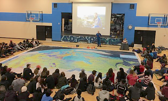
On October 17, 2016, CSA astronaut David Saint-Jacques was at Inuksuk High School, in Nunavut, to present a new educational activity as part of the Canada from Space giant floor map initiative. This activity is the first of a series of five geared towards northern communities.
(Credit: Canadian Space Agency)
We're not talking about the kind of map that you can fold up and put in your car's glove box, or track using your pocket-size smart phone. Today, Canadian Space Agency (CSA) astronaut David Saint-Jacques brought a whole new concept to Inuksuk High School, in Nunavut. He presented a new educational activity as part of the Canada from Space giant floor map initiative. This Earth observation activity is the first of a series of five geared towards northern Canadian communities.
The new activity is the result of collaboration between the CSA, the Royal Canadian Geographical Society, Inuit Tapiriit Kanatami and teachers from northern communities. It reflects the realities and uniqueness of the North. Students will learn about space technology while gaining an understanding of the many uses of Earth Observation satellites, such as ice monitoring, resource management and navigation.
As Canada prepares for the 150th anniversary of Confederation in 2017, the Government invites Canadians to experience and learn more about their environment and heritage. The Honourable Navdeep Bains, Minister of Innovation, Science and Economic Development said, “Through activities like the Canada from Space initiative, we hope to spark young Canadians’ interest in pursuing studies and careers in science, technology, engineering and math [STEM]. Through this activity, we are combining the uniqueness of the Northern identity and the subject of space to inspire the young people of Canada’s North to become our next generation of engineers, scientists and astronauts.”
What will begin in November 2016, three maps and sets of activities will be touring classrooms in Nunavut, Nunavik and Nunatsiavut. Two of these maps and new activities will start touring in the Northwest Territories and Yukon in 2017.
Since September 2014, the Canada from Space initiative has brought giant maps of Canada to approximately 16,000 students in Canadian classrooms. The maps are accompanied by activities designed to teach students how data obtained from Earth observation satellites play a role in their everyday lives. Each of the maps is a mosaic of 121 images of Canada taken from space by Canada’s Radarsat-2 satellite.