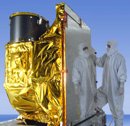
GOES-R, scheduled for another launch attempt on November 19th, will provide more detailed, accurate and rapid weather information than what is available from NOAA’s current geostationary weather satellites when on orbit.

Aboard will be Harris Corporation’s (NYSE:HRS) new Advanced Baseline Imager (ABI) weather instrument. Additionally, an enterprise ground system will be a key component of the GOES-R system. The Harris ABI, the main payload on GOES-R, is a high-resolution digital camera flying 22,300 miles above the Earth. The ABI will increase image resolution to one-tenth of a square mile, or four times better than current imagers. More filters, or spectral bands, on the ABI will detect more information about volcanic ash, dust, clouds, winds, fires, rainfall rate, and hurricane intensity than today’s geostationary weather satellites. Critical information about severe weather events can come as fast as 30 seconds, five times faster than today.
The Harris-built enterprise ground system will direct the satellites, operate the six satellite instruments, including the ABI, and process the significant increase in new data. It will process more data than all of the current GOES satellites combined, with one satellite producing 1.75 terabytes of data products daily for the National Weather Service and other users.
The ground system is comprised of equipment in three locations—Suitland, Maryland; Wallops, Virginia; and Fairmont, West Virginia—and includes 300 racks of computers and network equipment, 62 miles of interconnecting cables and six 16.4 meter antennas.
According to Eric Webster, the Vice President and GM Harris Environmental Solutions, GOES-R will advance environmental monitoring significantly, marking a quantum leap from 1990s technology into the 21st century. The detail, quality and speed of information coming from the new imager and processed through the Harris ground system will be game changers for meteorologists, the airline industry and other markets dependent on accurate and timely weather forecasts.Processing and moving all this data quickly enables forecasters to truly reap the benefits of the ABI. If the information is delayed, that could mean the difference between life and death in severe weather situations, such as tornadoes. The National Weather Service will receive updated information every 30 seconds in the fastest scanning mode.

