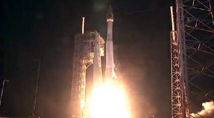

The US Air Force and their mission partners have successfully launched the third Space Based Infrared System Geosynchronous Earth Orbit satellite on an United Launch Alliance Atlas V Evolved Expendable launch Vehicle from Space Launch Complex 41 at Cape Canaveral Air Force Station, Florida at 7:42 p.m. EST.
The spacecraft separated from the upper stage approximately 43 minutes after launch. Following separation, the spacecraft began a series of orbital maneuvers to propel it to a geosynchronous Earth orbit. Once in its final orbit, engineers will deploy the satellite's solar arrays and antennas. The engineers will then complete checkout and tests in preparation for operational use.

The U.S. Air Force’s 45th Space Wing supported United Launch Alliance’s successful launch of the third Space Based Infrared Systems Geosynchronous Earth Orbit spacecraft aboard an Atlas V rocket from Launch Complex 41 at Cape Canaveral AFS.
The SBIRS program is managed by the Remote Sensing Systems Directorate at the Space and Missile Systems Center at Los Angeles Air Force Base, California. Lockheed Martin Space Systems Company, Sunnyvale, California, is the SBIRS prime contractor, and Northrop Grumman Aerospace Systems, Azusa, California, is the payload developer. The 460th Space Wing at Buckley AFB, Aurora, Colorado, operates the SBIRS system.

The SBIRS program delivers timely, reliable and accurate missile-warning and infrared surveillance information to the president of the United States, the secretary of defense, combatant commanders, the intelligence community and other key decision makers. The system enhances global missile launch detection capability, supports the nation's ballistic missile defense system, expands the country's technical intelligence gathering capacity and bolsters situational awareness for warfighters on the battlefield.
"The hard work and dedication of the launch team has absolutely paid off," Col. Dennis Bythewood, director of the Remote Sensing Directorate said. "Today's launch of GEO Flight 3 culminates years of preparation by a broad
team of government and industry professionals."
"While launch is a tremendous milestone, we are very focused on certifying GEO Flight 3 for operations and enhancing Overhead Persistent Infrared (OPIR) to meet emerging threats," Col. Shannon Begeman, SBIRS chief engineer said. "Infrared sensing is a mission area that continues to grow every day. We are just scratching the surface of what these sensors can do. GEO Flight 3 will be a fantastic addition to support the OPIR Battlespace Awareness Cell, ensuring we fully utilize the sensor capabilities for the benefit of the intelligence community and combatant commanders in need of enhanced battlespace awareness."

Air Force Space Command's Space and Missile Systems Center, located at Los Angeles Air Force Base in El Segundo, California, is the U.S. Air Force's center for acquiring and developing military space systems. Its portfolio includes GPS, military satellite communications, defense meteorological satellites, space launch and range systems, satellite control networks, space-based infrared systems, and space situational awareness capabilities.

