
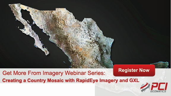
[Satnews] PCI Geomatics is presenting another in their "Get More From Imagery Webinar Series" — this new event is entitled "Creating a Country Mosaic with RapidEye Imagery and GXL."

PCI Geomatics, together with partner the National Comisión for the Knowledge and Use of Biodiversity (CONABIO), recently revealed a complete mosaic of Mexico which was produced by a single operator based on more than 25,000 RapidEye images through the use of a GXL large volume image production system.
The following topics will be covered in this webinar:
- Introduction to BlackBridge, and RapidEye imagery, key advantages
- Case study walk through - processing the Mexico Mosaic
- CONABIO’s experience using RapidEye imagery and GXL software
- Background on CONABIO and use of Earth Observation
- Techniques applied to handle image selection (cloud cover, seasonality)
- Editing seamlines
- Automated color balancing approaches
- Reducing hot spots
- Adjustments applied, editing
- Publication of the Mosaic, use in Mexico
- Live demonstration / review of Mosaic processing environment
The webinar will be held on the following dates and times:
December 8, 2015, at 9:00 a.m., EST (14:00 GMT)
December 9, 2015, at 4:00 a.m., EST (09:00 GMT)
Please access this direct link to register for this informative webinar...