

East View Geospatial (EVG) has released their most up-to-date global imagery basemap, PlanetSAT Global #2018, which is a collaborative effort with EVT partner PlanetObserver. The data has a 10-meter resolution and provides accurate geographic information for any part of the world. Users benefit from a seamless view of the Earth that is improved with recent cloud-free satellite imagery in high-quality natural colors.
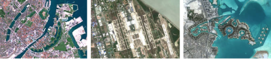
The multi-source data that was selected for producing version #2018 of PlanetSAT Global Mosaic was very recent Sentinel-2 imagery at 10-meter resolution to update all the largest urban areas across the world and all capital cities. Additionally, continents were updated with new Landsat 8 imagery that is color-corrected, optimized and ready-to-use in multiple formats. PlanetSAT Global #2018 mosaic is available in global, continental, country or custom AOI coverage, and can be delivered in GeoTIFF, JPEG or ECW format.
PlanetSAT Global #2018 mosaic is an asset to users across different industries, and the mosaic is easy to use in many military, commercial and consumer applications for visualization and simulation solutions, aircraft simulators, geo-intelligence solutions, web-mapping apps, and weather graphics systems.
Laurent Masselot, CEO of PlanetObserver said that with PlanetSAT Global Version #2018, they offer a completely improved product with higher spatial resolution and more recent imagery. On top of that, users save time with ready-to-use imagery, easy to implement in their solutions.
East View, founded in 1989 and headquartered in Minneapolis, Minnesota, is comprised of East View Information Services, East View Geospatial and East View Map Link, providing maps and geospatial data and Russian, Arabic and Chinese-produced social and hard science content.