

[Satnews] DigitalGlobe, Inc. (NYSE: DGI) is delivering crowdsourced damage assessments derived from satellite imagery to the government of Fiji in response to the devastating cyclone that struck the island nation on February 20.
Beyond imagery alone, DigitalGlobe is committed to helping the government of Fiji make critical decisions where lives, resources, and time are at stake.
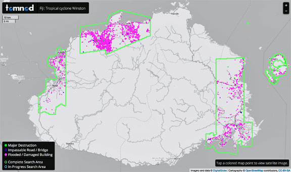
Before the powerful storm reached Fiji’s coast, DigitalGlobe activated its FirstLook service and began making preparations to capture the world’s first glimpses of Cyclone Winston’s impact. Despite lingering cloud cover, DigitalGlobe’s constellation of high-resolution satellites collected the first images within 24 hours of the storm’s landing. The satellite images were immediately loaded onto DigitalGlobe’s public crowdsourcing platform, Tomnod, where an online community of volunteers began to search the imagery for impassable roads, damaged buildings, and areas of major destruction.
To date, the crowd has searched through more than 5,400 sq. km. of high-resolution, high-accuracy imagery and identified 5,500 unique points of interest that are helping the Fiji government and the Secretariat of the Pacific Community (SPC) organize a multi-agency relief effort. Fresh imagery and crowd-sourced results are being delivered in near real-time as the crowd searches through new areas each day.
Tropical Cyclone Winston made landfall as a category 5 storm with sustained winds of 230 kilometers per hour, making it the most powerful storm ever recorded to hit the island nation. More than 40 people have been killed and tens of thousands of people have been left homeless. The Tomnod campaign will remain active until the entire area of interest, as defined by the Fiji government, has been fully crowdsourced.
“With more than 100 inhabited islands scattered across thousands of square kilometers of open ocean in the South Pacific, Fiji faces unique challenges when it comes to disaster response and recovery,” said Caitlyn Milton, DigitalGlobe’s Crowdsourcing Manager. “The pointing agility and broad area collection capacity of our satellites enabled us to quickly image many of the affected islands. Only with DigitalGlobe’s high-resolution, high-accuracy imagery can the Tomnod crowd pinpoint the location of every damaged or flooded building and every impassable road and bridge, features that cannot be reliably detected in lower resolution imagery.”
“DigitalGlobe is a trusted partner of the Secretariat of the Pacific Community, and we appreciate their support, as well as the efforts of the many Tomnod volunteers who have contributed to the response to Cyclone Winston,” said Michael Petterson, Director of the SPC’s Geoscience Division. “By working jointly to collect, analyze, and distribute this information to response agencies, we are ensuring that aid reaches those who have been affected in the most efficient way possible.”
Join the online Tomnod community of volunteers and help to map damage across Fiji: http://www.tomnod.com/campaign/fiji_winston_2016
Explore a sample of the current results via this interactive map: http://admin.tomnod.com/campaign/fiji_winston_2016/results