[SatNews] ...tall, cauliflower-shaped clouds that billowed up above the smoke.
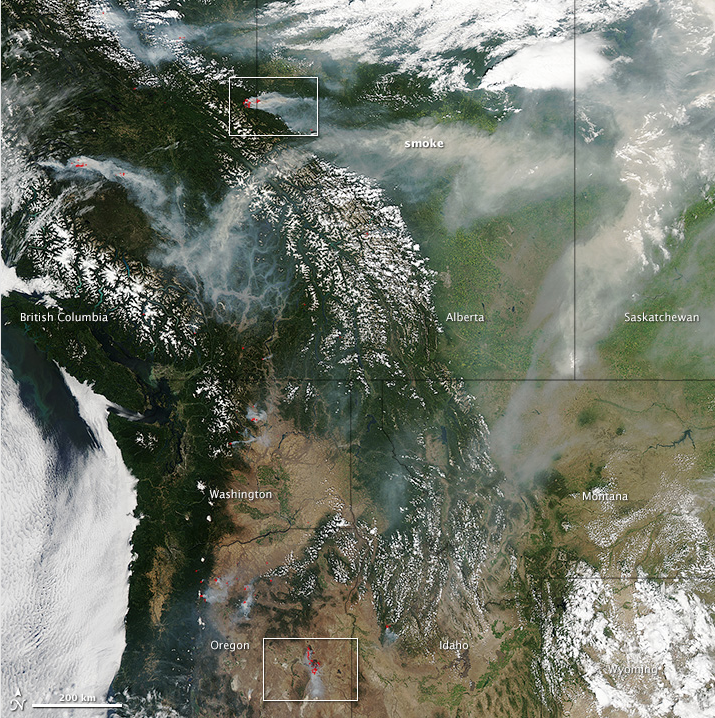
A combination of lightning, parched forests, and hot temperatures fueled dozens of wildfires in Canada and the northwestern United States. According to the Canadian government, 102 uncontrolled fires were burning in British Columbia on July 17, and there were 13 more in Alberta. Across the border, 33 uncontrolled fires were active in Washington and Oregon.
The Moderate Resolution Imaging Spectroradiometer (MODIS) on NASA’s Aqua satellite captured the top image on July 16, 2014. Dense plumes of smoke billowed from many of the blazes. Actively burning areas, detected by the thermal bands on MODIS, are outlined in red. Forests appear dark green. The snow-capped peaks of the Canadian Rockies are visible in the center of the image. Large banks of white clouds hover over the Pacific Ocean, northern Alberta, and Wyoming. Winds pushed long plumes of smoke east toward Alberta and into Saskatchewan.

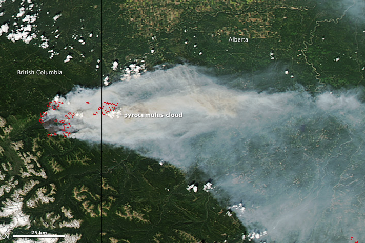
The middle image is a closer view of the complex of fires burning near near Chinook Ridge, on the border of British Columbia and Alberta. In addition to producing thick smoke, the fires fueled multiple pyrocumulus clouds—tall, cauliflower-shaped clouds that billowed up above the smoke. Pyrocumulus are similar to cumulus clouds, but the heat that forces the air to rise—which leads to cooling and condensation of water vapor—comes from fire instead of the Sun-warmed ground. In satellite images, pyrocumulus clouds appear as opaque white patches hovering over darker smoke.
Scientists monitor pyrocumulus clouds because they can inject smoke and pollutants high into the atmosphere. As pollutants are dispersed by wind, they can affect air quality far away from their source area. As noted by the UMBC Smog Blog, smoke from British Columbia was merging with smoke from fires in the Northwest Territories and contributing to diminished air quality over Canada and parts of the United States.
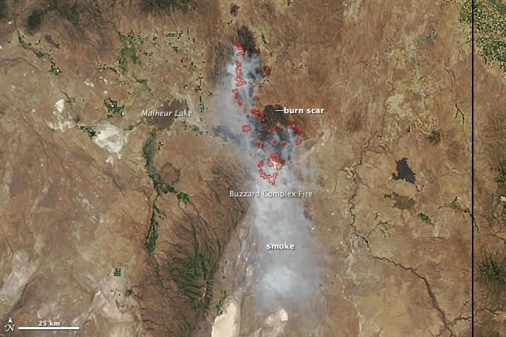
The third image shows a closer view of the Buzzard Complex Fire, the largest active fire in Oregon. Ignited by lightning on July 14, it had charred 180,975 acres (732 square kilometers) as of July 17. Unlike the fires in Canada—which were burning primarily in forests—the Buzzard Complex Fire was moving through brush and grass.

References and Related Reading
- Canadian Interagency Forest Fire Center (2014, July 17) National Wildland Fire Situation Report: July 17, 2014, 15:00 Hours. Accessed July 17, 2014.
- CBC News (2014, July 16) B.C. wildfire roundup: evacuation orders and alerts. Accessed July 17, 2014.
- Climate Central (2014, July 17) Fires in NW Territories in Line with “Unprecedented.” Burn. Accessed July 17, 2014.
- CNN (2014, July 17) Hundreds evacuated as Washington wildfire grows. Accessed July 17, 2014.
- Global News (2014, July 15) INFOGRAPHIC: How do this summer’s wildfires compare to previous years’? Accessed July 17, 2014.
- Huffington Post (2014, July 14) Heat Wave In B.C. Brings Wildfires, Air Quality Advisory. Accessed July 17, 2014.
- InciWeb (2014, July 15) Oregon. Accessed July 17, 2014.
- Mashable (2014, July 17) WTF, Summer? It’s 103 Degrees in Canada, 55 in Missouri. Accessed July 17, 2014.
- The Oregonian (2014, July 17) Wildfires force more evacuations in central Oregon. Accessed July 17, 2014.
- University of Maryland-Baltimore County Smog Blog (2014, July 17) Heavy Smoke over Canada and Pacific Northwest. Accessed July 17, 2014.
- University of Wisconsin CIMSS PyroCb blog (2014, July 15) Multiple PyroCb’s in northwestern Canada. Accessed July 17, 2014.
- The Wall Street Journal (2014, July 17) Firefighters Face Dozens of Blazes Across the West. Accessed July 17, 2014.
NASA image courtesy Jeff Schmaltz, LANCE/EOSDIS MODIS Rapid Response Team at NASA GSFC. Caption and image cropping by Adam Voiland.
Instrument(s):
Aqua - MODIS

