
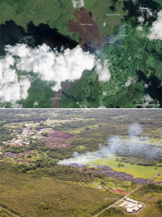
NASA Earth Observatory image by Jesse Allen, using EO-1 ALI data provided courtesy of the NASA EO-1 team and the U.S. Geological Survey. Aerial photograph of the U.S. Geological Survey Hawaiian Volcano Observatory. Caption by Adam Voiland.
[SatNews] For several weeks, residents of the Hawaiian town of Pahoa have been warily watching an unusual flow of lava from Kilauea grow closer and closer to their community.
Lava from Kilauea normally flows south toward the ocean, but the June 27 lava flow has moved in a northeasterly direction instead after several new fissures opened up on the northeast flank of Kilauea’s Pu‘u ‘O’o crater earlier this summer. While the flow moved in fits and starts in September and October as it moved through a forested area southwest of Pahoa, lava entered residential property for the first time on October 28, 2014. The Advanced Land Imager (ALI) on NASA's Earth Observing-1 (EO-1) satellite captured this image of lava approaching the town on October 24, 2014. The lava flow appears gray. By October 25, the flow had cut across Apa‘a Street.
During an aerial survey on October 27, 2014, the Hawaiian Volcano Observatory captured the lower photograph. It shows the path of a narrow finger of lava as it was heading for a more densely-populated part of Pahoa. The flow was reportedly advancing by about 15 feet (5 meters) per hour.