

Following a decision of the EUMETSAT Council back in of June 2016, Meteosat-8 replaced Meteosat-7 as the EUMETSAT geostationary satellite observing the Indian Ocean on February 1, 2017.
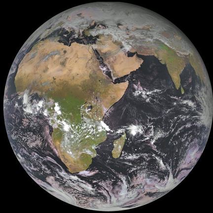
The first operational image of the Indian Ocean region taken by Meteosat-8. Image is courtesy of EUMETSAT.
The Meteosat-8 satellite belongs to the second generation of Meteosats and is much more capable than the first generation Meteosat-7 and delivers imagery from 12 instead of 3 spectral channels, with higher spatial resolution and with an increased frequency, every 15 instead of every 30 minutes. Of the 12 spectral channels, 11 provide measurements with a resolution of 3 km at the sub-satellite point. The twelfth, so-called High Resolution Visible channel, provides measurements with a resolution of 1 km.
In the context of the World Meteorological Organisation’s Integrated Global Observation System and in partnership with India, Russia and China, EUMETSAT thereby continues the organization's best effort contribution to observations of the Indian Ocean from geostationary orbit.The partnership provides more resilient, integrated Indian Ocean Data Coverage (IODC) services with optimum regional coverage, including a joint suite of essential meteorological products made available to all users worldwide.
For optimum synergy with the Indian INSAT-3D satellites located around 82° East and with Meteosat-10 located at 0°, Meteosat-8 operates at 41.5°East, instead of 57.5° East, The synergy with Meteosat-10 brings additional benefits to EUMETSAT users in Africa and Central and Eastern Europe. The Meteosat-8 image data is delivered in real time over Europe and Africa via EUMETCast, EUMETSAT’s flexible dissemination system for environmental data, and are exchanged with IODC partners.