

East View Geospatial (EVG), a provider of content-rich cartographic products, continues to enhance the accuracy of automated feature identification using its newly developed training data sets in supervised machine learning applications.
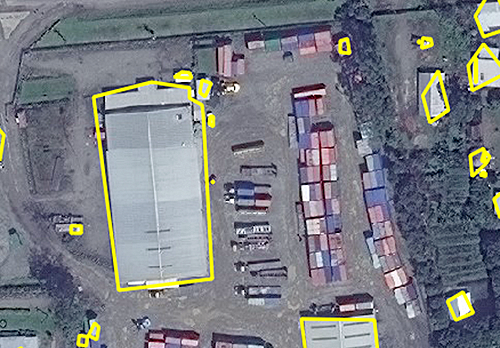
Supervised machine learning results generated from satellite imagery and EVG training data identified structure footprints as polygons in Papua New Guinea.
The early results pertained to automated recognition of building structures in an ongoing pilot project in Papua New Guinea (PNG). EVG will be available to discuss the PNG pilot in private meetings next week at the 2017 GEOINT Symposium in San Antonio. Sample data sets are being offered at no charge.
EVG initiated the PNG pilot early this year with multiple organizations actively engaged in enhancing and calibrating big data algorithms. Most supervised machine learning applications in geospatial currently entail either automated extraction of information from massive data sets or management and tracking of high-velocity, high-volume data streaming from numerous remote sensing platforms.
In its early phases, the pilot has concentrated on developing foundational training data sets tailored to identification of transportation, hydrology, infrastructure and land use/land cover in half-meter satellite imagery. EVG and its partners are now expanding their research to include imagery and streaming video from other sources, including aircraft, unmanned aerial systems (UAS), and terrestrial sensors.