


An historical moment as the first of the first shares the news. The first Sentinel 1A radar satellite transmits its first image...
EDRS-A, the first relay satellite for the EDRS-SpaceDataHighway program, launched on January 30, 2016, successfully transmitted the first image taken by the Sentinel 1A radar satellite. The image, taken over La Reunion Island and its coastal area, was transmitted and received by the Airbus Defence and Space’s Mission Operation Center (MOC) in Germany in about 1 minute. The orbital testing program being carried out by the Airbus Defence and Space engineers is running nominally and confirms that the operational start of service will take place in July 2016.
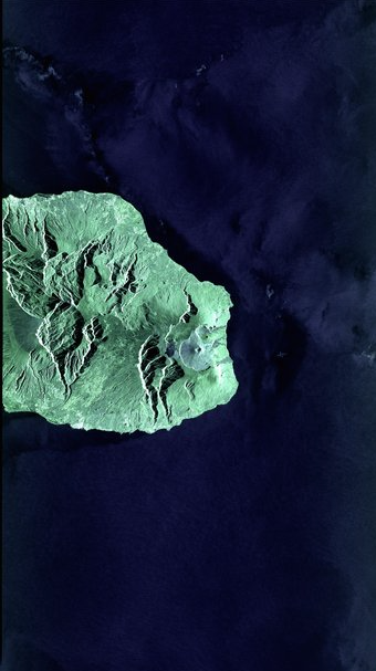
La Reunion Island via laser Released 01/06/2016 11:34 am Copyright Copernicus Sentinel data (2016), processed by ESA Sentinel-1A radar satellite test image taken on May 26, 2016, recorded and relayed to Earth by EDRS-A on May 31, 2016 via laser. The image covers the island of La Reunion and surrounding waters, and was acquired in ‘Stripmap’ mode. A false-color composite based on the radar’s two polarization channels.

The SpaceDataHighway system will provide high-speed laser communication in space at up to 1.8 gigabits per second. This major program, which cost nearly €500 m to develop, is the result of a public-private partnership (PPP) between the European Space Agency (ESA) and Airbus Defence and Space.
Thanks to the laser technology developed by Tesat Spacecom, an Airbus Defence and Space subsidiary, the SpaceDataHighway will be able to transfer high-volume information from Earth observation satellites, UAVs and surveillance aircraft, or even from a space station such as the ISS. Thanks to the very high communication rates possible with lasers (up to 1.8 Gbit/s) and the geostationary orbit positioning of the relay satellites, up to 50 terabytes per day can be transmitted securely in near-real-time to Earth, as opposed to the delay of several hours currently experienced.
The European Commission will be the first customer of the SpaceDataHighway system. The Sentinel-1 and Sentinel-2 satellites of Copernicus, the European Earth observation program, are equipped with laser communication terminals that will significantly accelerate the delivery of time-critical data and large volumes of data to Earth monitoring centers. In case of crisis or natural disaster management, up-to-date information is crucial for the authorities to prepare the most appropriate emergency response.
"SpaceDataHighway is no longer science fiction. It will revolutionize satellite communications, and help to keep the European space industry at the forefront of technology and innovative services," said Evert Dudok, Head of the Communications, Intelligence & Security (CIS) business line at Airbus Defence and Space.
Magali Vaissiere, ESA Director of Telecommunications and Integrated Applications, said at the Berlin Airshow today, "With today’s first link, EDRS is close to becoming operational, providing services to the Copernicus Sentinel Satellites for the European Commission."
As lead contractor of the SpaceDataHighway PPP, Airbus Defence and Space co-finances, designs, manufactures and operates the system as well as commercializing it. The German national aeronautics and space research center (DLR) is also participating in financing the system and also in the development and operation of the ground segment. Eleven European countries are also involved in the consortium.
Positioned at 9 degrees East, this first communication node of the SpaceDataHighway system will be able to establish laser links with orbiting observation satellites and UAVs positioned over Europe, Africa, Latin America, the Middle East and the eastern coast of North America. A second satellite will be launched in 2017, which will extend the coverage, capacity and redundancy of the system. Airbus Defence and Space and ESA are looking for partnerships to further expand the SpaceDataHighway program by 2020, with a third node to be positioned over the Asia-Pacific region. The Pacific Rim region, for instance, has witnessed its communication needs for airborne missions rise dramatically.
http://www.edrs-spacedatahighway.com