

Globalstar Europe Satellite Services Ltd., a wholly owned subsidiary of Globalstar Inc. (NYSE: GSAT) got some special attention from The Duke of Edinburgh’s Award (DofE) Charity. The charity has signed a new three-year exclusive contract with Globalstar's value added reseller, Mapyx, to provide tracking using the SPOT Gen3 satellite tracker.
The tracker is important as every year over 300,000 young people take part in DofE expeditions across the UK countryside. With the combination of SPOT Gen3 devices and Mapyx’s mapping and tracking solution, leaders can track the location of each expedition group of five to seven participants, while each group can send standard messages and request help whenever required.
Scores of teachers, parents and expedition organizers enjoy peace of mind as hundreds of UK schools and more than 10,000 young people rely on Mapx tracking. It also provides satellite tracking and SOS for school trips to regions of the world with unreliable mobile communications including the Himalayas and Mount Kilimanjaro.

The Mapyx and SPOT solution gives organizers a complete picture of each group’s journey and location that means the staff no longer have to waste hours waiting for groups to arrive at checkpoints or worrying about their safety. Staff can maintain their distance while still having an overview of the participants’ progress.
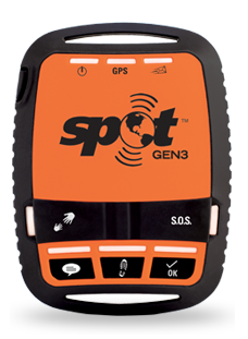
The affordable, rugged, pocked-sized SPOT Gen3 allows DofE participants to send pre-programmed messages to expedition organizers, for example, letting them know they have arrived at a checkpoint; are taking a break; or require help. If the worst should happen, the participants can simply press the one-touch SOS button to send their GPS location to initiate emergency response procedures. Mapyx then works with GEOS International Emergency Response Coordination Centre (IERCC) and, if required, UK Mission Control Centre (UKMCC) and Maritime Coastguard Agency (MCA) to manage the emergency response.

Mapyx offers a full search management, control system and tracking interface that uses Ordnance Survey maps, aerial imagery and even building plans. Unlike the basic service offered on Google Maps, Mapyx provides extra local terrain conditions and useful local details such as landmarks that can provide valuable help in a rescue situation.
Dave Wells, RAF Volunteer Reserve Training Branch Squadron Leader and Deputy Regional DofE Officer, Wales and West Region, commented that they have used Mapyx and SPOT technology for about three years and have found it to be incredibly useful. They can keep track of groups with minimum physical interaction thus enriching the experience of the participants. The safety factor makes them more secure in the application of their duty of care. As an example, one summer they had a gold group near Capel Curig in Snowdonia and the weather had deteriorated. When one participant slipped and sprained her ankle, the group used SPOT to send a help message. Because SPOT sent the group’s exact GPS position, the volunteers were able to get to them in a 4x4 and evacuate the injured girl within 20 minutes. Given the conditions, the least time spent immobile the better. The rest of the group was then able to proceed and complete their expedition.
Peter Schooling, DofE Commercial Director added that they have partnered with Mapyx for five years and in that time have contributed towards the safe running of expeditions for many DofE participants as they hike across some of the UK’s most challenging terrain. On the back of this successful partnership they have extended their contract with Mapyx for a further three years. They first partnered with Mapyx when they saw how organizations including Mountain Rescue, the Ministry of Defence and fire services were using Mapyx and SPOT trackers to make their search and rescue operations so much more effective.