
MarSat has devised solutions to challenges that face the maritime industry — a new service provides detailed data on sea ice in polar regions where internet connections are slow, improves electronic navigational charts for poorly surveyed waters and adds software solutions to support maritime decision-making with satellite data.
Increasing safety and efficiency and reducing the risk of maritime operations has been, and still is, one of the company's core ambitions. In recent years, MarSat has developed and evaluated solutions to aid planning and routing in higher latitudes, to increase safety of navigation in areas which were inadequately surveyed and developed relevant information portals and software solutions. Now, MarSat has formed a German consortium with expertise in satellite analytics, on-board software and hardware development, all with deep understanding of the maritime market.

The MarSat team includes the satellite data service providers EOMAP and Drift+Noise Polar Services, maritime hardware and software providers SevenCs and TRENZ and the Institute of Shipping Economics and Logistics (ISL).
In July 2019, the partners officially completed the R&D stage of the MarSat project, funded by the German Federal Ministry for Economic Affairs and Energy. This does not mean that MarSat has come to an end — instead, the company is proud to have reached the next, mature level.
 One of the demands of the maritime industry is the ability to access data and perform analysis in-house, as and when they need it. As a partner in MarSat, EOMAP has developed cloud-based software solutions to harness satellite data through modern data analytics methods in combination with physics-based procedures. The company has also created easy-to-use tools to aid maritime decision making, including information portals especially for the maritime industry. These harvest available data such as global sea-state models and also allow users to access very high-resolution data from satellites. For example, the dredging industry uses these services to support sediment monitoring and seafloor characterization.
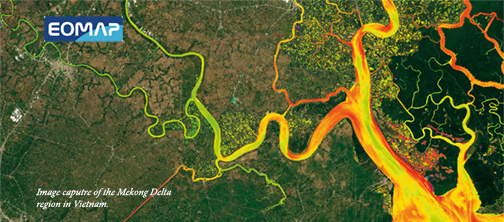
Satellite-Derived Bathymetry calculates water depth for shallow waters using sunlight reflected from the seafloor and recorded by satellite sensors. Although the technique has been investigated since the 1970s, it required modern satellite capabilities and advances in computing power to bring SDB, as it is often called, to the broader community.
Dr. Knut Hartmann, Project Manager of MarSat and COO of EOMAP, reported that the organization is finding a steady growth in uptake of Satellite-Derived Bathymetry. Most applications are in planning and management of coastal zone environments and in engineering. Hydrographic applications have been less common so far, although some hydrographic offices are starting to systematically integrate SDB into their surveys. The MarSat team has generated high-resolution and dense-contour electronic navigational charts (ENCs) complying with current standards. These charts are especially helpful to mariners in areas which are inadequately surveyed.
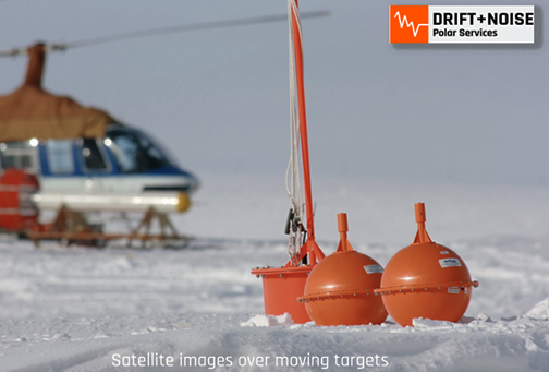
Dr. Lasse Rabenstein, the CEO of Drift+Noise Polar Services GmbH, a company specializing in the mapping of polar ice, said that smarter routing in higher latitudes is not science fiction anymore. Fully automated, 24/7, near real-time ice image information for polar waters is available right now. The company's support system for tactical decision-making includes an operational satellite image database; communication channels between ships, satellites and the internet; the automatic ship identification system (AIS) and the Ice Pad. The Ice Pad is a hardware device developed to transfer satellite imagery and ice data to ships, including areas where only a low-bandwidth Iridium connection exists. Among other things, the company has supported the Weddell Sea Expedition 2019 to Antarctica, conducted by an international team of researchers on the South African research ice-breaker S.A. Agulhas II. The Ice Pad was a great success and it provided the ship's captain with ice information which he would not have so easily accessed without this technology.
Frank Diegel, the CEO of TRENZ GmbH, a maritime IT company, added that the Ice Pad is new to the community and a big step toward greater efficiency and safety in the polar region. For TRENZ, it was the first time the company had integrated near real-time satellite information into the firm's software and hardware solutions and the company is proud of the interdisciplinary achievements of the team.
Friedhelm Moggert-Kägeler of SevenCs GmbH, a maritime software company, noted that the company had been aware of Satellite-Derived Bathymetry for some time and were attracted by the simplicity of the approach. Using satellite data to survey shallow waters brings so many advantages compared to labor- and equipment-intensive acoustic campaigns. The firm had questions about how this technology could be brought to the mariners, how it performs with S100 standards and where it brings the most benefits.
Dr. Thomas Heege, CEO of EOMAP, commented that time is a pressing issue for users — we developed solutions which allow them to enter the fascinating world of satellite analytics without having to understand its complexities. Simply open a browser and enter a data query or begin an analysis.
MarSat is co-financed by DLR Space Administration (part of the German Aerospace Center), with funds from the Federal Ministry for Economic Affairs and Energy (BMWi) of Germany. The funding period ended in mid-2019 but the MARSAT consortium is continuing to bring innovations to market.