
[SatNews] The accuracy of the information contained in each pixel identifies which type of boats is present in the harbor, and therefore, their nationality.
Military commanders typically operate in high-tempo environments and feed off a variety of intelligence sources to reach their decisions. Good intelligence leads to better situational understanding and hence improved knowledge, which will ultimately underpin optimum decision-making. This good intelligence can only be achieved with up-to-date and accurate data provided by satellites such as Pléiades.
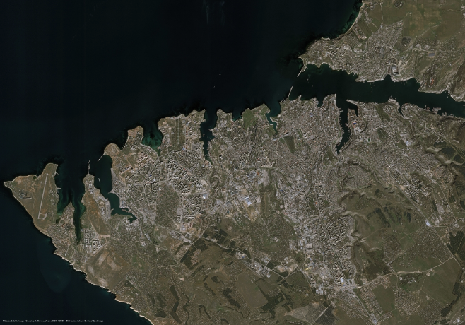
Pléiades Satellite Image - Sevastopol Ukraine on 3rd March 2014
Airbus Military, Astrium and Cassidian are now Airbus Defence and Space, which provided these photos and other capabilities to assist with the ongoing challenges, and meet the needs in today's world. Learn more about this and other capabilities here.
Owing to their greater agility, and capacity to capture a larger collection of images, Pléiades 1A and Pléiades 1B become key elements within crisis management and military operations.
Placed in a 180-degree phased orbit, the twin satellites have daily revisits over most locations on Earth. Furthermore, thanks to their Control Moment Gyroscop (CMG), the satellites can pitch and roll forward, backward and sideways up to 45 degrees very quickly. This remarkable agility enables them to capture a multitude of individual scenes, long strips, or broad contiguous areas of interest on a single pass. The CMG effectively extends the swath widths from 20 to 120 km! This has drastically improved customer access to their area of interest and reduced imagery delivery delays.
Recently, following the first Russian troops movements in the Crimean region, Pléiades was tasked to prioritize collection on the most important hot spots: airbase, naval base, military barracks, roads and strategic bridges and railways. Within less than 24 hours from receipt of the tasking request on 3 March to the satellite imagery delivery on 4 March, Pléiades provided a 50cm-detailed level on Sevastopol, allowing objective situation analysis. The accuracy of the information contained in each pixel allows identifying which type of boats is present in the harbor, and therefore, their nationality. One can also clearly see on the image, the blockade of Ukrainian warships in some parts of the area, the presence of military convoys and troop formation.
Pléiades provides daily revisits, and three tasking plans per day, to provide geo-intelligence analysts with the freshest images on their specific target sites.