
[SatNews] A trio of stations has taken shape on three islands at the far corners of our continent, ready to capture distress calls via satellite from across Europe and the surrounding waters.
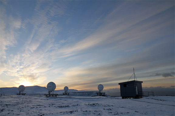
The station at Spitsbergen in the Norwegian arctic.
Photo courtesy of ESA.
The ground network for Galileo’s search and rescue service has now passed a major exam, coming a step closer to saving lives. These stations sit on Spitsbergen in the Norwegian Arctic, Maspalomas on the largest island of Spain’s Canary Islands, and Larnaca on the island nation of Cyprus, forming a triangle enclosing Europe. The three are coordinated and overseen from a control centre in Toulouse, France.
Each site is equipped with four antennas to detect distress calls relayed via satellites in medium-altitude orbits, currently including 14 GPS satellites, two European Galileos and one Russian Glonass.The three stations are interlinked to operate jointly, so that the 12 antennas can track satellites together. A summer of testing has confirmed the heightened efficiency of this approach.
“This new search and rescue infrastructure, designed by ESA and financed by the EU as part of Galileo, is our contribution to the Cospas–Sarsat system, the world’s oldest and largest satellite-aided rescue system,” said ESA’s Fermin Alvarez Lopez.
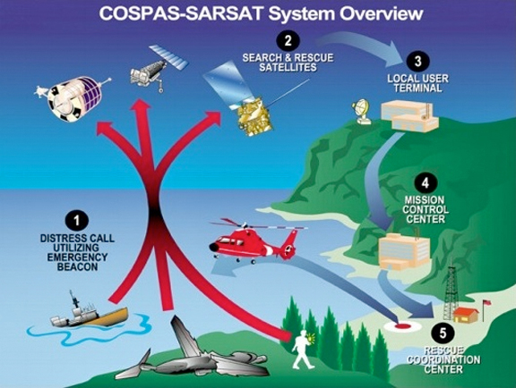
For three decades the Cospas–Sarsat system has used transponders on satellites such as Europe’s MSG and MetOp to pick up distress calls from ships and aircraft.
Image courtesy of COSPAS-SARSAT.
Founded by Canada, France, the USSR and the U.S., Cospas–Sarsat is a global satellite system for rapidly detecting distress calls to be forwarded to local search and rescue authorities. Since its creation in 1979, it has helped to rescue more than 35 000 people.Cospas–Sarsat distress beacons can be purchased off the shelf, then activated by anyone in distress on land, in the air or on the sea. Satellite repeaters pick up and amplify the beacon signals, then transmit them down to ground stations. These stations identify the approximate location of the signal and then pass the information to the rescue authorities.
“Up until now, Cospas–Sarsat has relied on satellites in low and high orbits,” said Fermin. “But medium orbits with satellites such as Galileo are better: they combine a wide field of view with strong Doppler shift, making it more likely a distress signal is pinpointed promptly and accurately.”
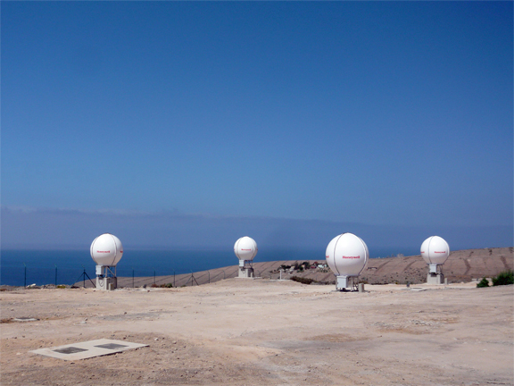
The ESA-built Maspalomas Medium-Earth Orbit Local User Terminal (MEOLUT) on Gran Canaria, the largest island of Spain’s Canary Islands, part of an extension of the international Cospas–Sarsat search and rescue program into medium-altitude orbits, spearheaded by Galileo.
Photo is courtesy of ESAS—Fermin Alvarez Lopez.
The broad coverage also means fewer ground stations are required—hence, three stations can handle the entire European service area. Once the stations were completed, testing began, Igor Stojkovic, ESA’s search and rescue engineer explained,: “We have been demonstrating the system performs as required, ahead of handing it over to its operator, part of France’s CNES space agency, in December ahead of service beginning in 2016.”
Distress beacons emit UHF bursts every 50 seconds. The stations are required to detect and locate all signals received to within 5km after 10 minutes.
For more information regarding ESA and navigation systems, please visit the infosite at http://www.esa.int/Our_Activities/Navigation