
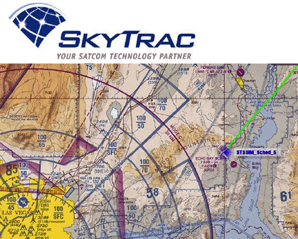
[SatNews] SkyTrac Systems is now offering Aeronautical Charts as an additional service to its world renowned web-based mapping system, SkyWeb.
All SkyWeb customers are being provided with a free 45 day trial of this new service, which will aid both pilots and ground crew in planning and monitoring flights. With the click of a mouse, customers can easily switch between traditional Google maps and the new VFR, High Altitude and Low Altitude charts. The use of Aeronautical Charts in combination with SkyWeb’s flight following, event notification and Flight Data Monitoring (FDM) capabilities will help aviation organizations streamline operations as they combine all flight information into a single source, without having to deal with paper maps or other online mapping systems. Aeronautical Chart data is refreshed every 28 days to ensure the most accurate and up to date information is provided to customers.
The SkyTrac infosite is located at: http://www.skytrac.ca/