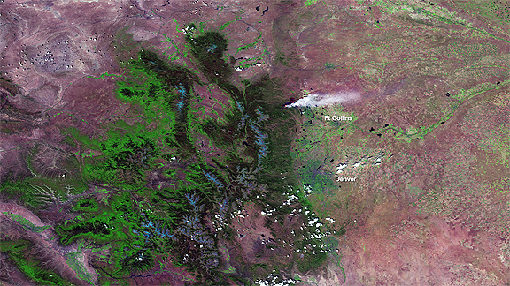
The U.S. Forest Service estimates that more than 20,000 acres have burned since the fire started on June 9th, and has increased 567 percent in size, from Sunday to Monday. One reason for this increase is the high amount of grass, brush, and trees that are fueling the fire. On June 10th at around 20:00 UTC, the NOAA-NASA Suomi NPP passed over the fire, shown here. The VIIRS sensor can use its many visible and infrared channels to differentiate between surface types. In this image, not only are the active fire areas and smoke visible, but also the different surface classifications. Vegetated areas are colored in shades of green: dark green are forested areas, bright green are grasslands. Blue areas are the snow-covered mountain peaks. Areas without vegetation (e.g., bare soil, urban areas) are colored in purple. Because the infrared sensors on VIIRS can detect the actual fire hotspots, those are visible as bright red-orange areas surrounding the smoke plume.