

[Satnews] Forty years ago, on October 16, 1975, NOAA’s first Geostationary Operational Environmental Satellite was launched from Cape Canaveral Air Force Station in Florida.
Known as GOES-A when it launched, the satellite was designated GOES-1 once operational. GOES-1 returned its first image only nine days later on October 25, and quickly became an essential tool used by the NOAA’s National Weather Service.
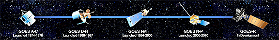
Before launch, NOAA assigns a letter to GOES satellites (-A, -B, -C…) and a number once it has achieved orbit. For example, GOES-O, once in orbit, was designated GOES-14, GOES-G, which was lost at launch, was never assigned a number.
Diagram is courtesy of NOAA.
Using a Visible/Infrared Spin Scan Radiometer (VISSR), the satellite provided day and night observations of cloud and surface temperatures, cloud heights and wind fields. Although GOES-1 was spin-stabilized, only viewing Earth about 10 percent of the time and providing data in only two dimensions, it gave forecasters their first near-real time look at atmospheric conditions from a fixed location. GOES-1 remained active throughout the launches of GOES-2-6, until finally being decommissioned on March 7, 1985.
Before launch, NOAA assigns a letter to GOES satellites (-A, -B, -C…) and a number once the craft has achieved orbit. For example, GOES-O, once in orbit, was designated GOES-14, GOES-G, which was lost at launch, was never assigned a number.
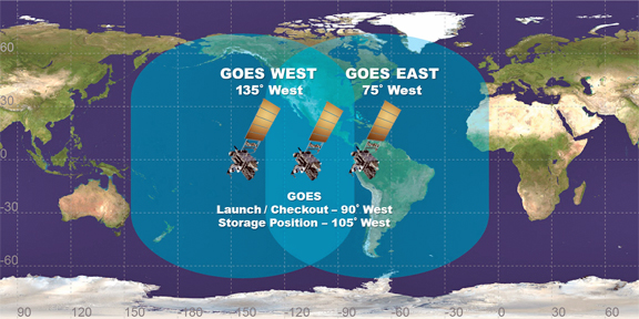
Operating from two primary locations, GOES-East and Goes-West, geostationary satellites orbit above the Earth at speeds equal to Earth’s rotation, allowing them to maintain their position and provide continuous coverage of one location.
The following generations of GOES satellites and their instruments continued to improve, experiencing significant enhancements, and have now provided continuous and accurate imagery and data on atmospheric conditions, solar activity, and Earth’s weather systems for 40 years. Over the decades, GOES have taken well over 3 million images!
Since the success of GOES-1, the GOES satellites have become forecasters’ eye in the sky, playing a vital role in providing imagery and data to forecast and track our nation’s most severe and potentially deadly weather events.
With the next generation of weather observing satellites on the horizon, NOAA is poised to once again significantly improve weather forecasting and severe weather prediction.The first satellite in this series of satellites, called GOES-R, is scheduled to launch in fall of 2016. Positioned above North America, GOES-R will scan the Earth five times faster at four times image resolution, and triple the number of channels scientists can tap into to observe global weather and climate. This increase in data production means satellite imagery of severe weather, such as hurricanes and tornadoes, will be available in near real-time, giving forecasters even more tools to make timely warnings during a severe weather event.
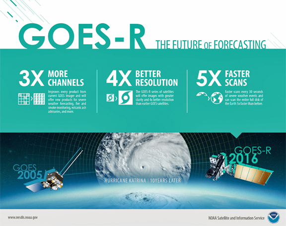
Image is courtesy of NOAA Satellite and Information Service.
The GOES-R series satellites will also carry the first lightning mapper flown from geostationary orbit. The Geostationary Lightning Mapper, or GLM, will map total lightning (in-cloud and cloud-to-ground) continuously over the Americas and adjacent ocean regions. Research has shown that lightning flash rate increases can be a predictor of impending severe weather and total lightning data from GLM has great potential to increase lead time for severe thunderstorm storm warnings.
 Image is courtesy o NOAA.
For more information on the GOES-R mission, be sure to visit the GOES-R homepage.
Providing data to support weather forecasting and monitoring Earth’s climate requires many types of satellites, however. The NOAA/NASA Suomi NPP satellite and the future JPSS constellation will work in tandem with GOES-R to provide vital information in the face of severe weather events.
For more information on the JPSS constellation, select this infopage link...