
[SatNews] The International Charter: Space and Natural Disasters has been activated by the UK in the wake of the persistent storms which have battered the country over Christmas and into the New Year, causing wide-spread flooding and tidal surges.
The Charter allows charitable and relief agencies to access a pool of free satellite data to assist with immediate disaster relief operations, and for creating accurate maps of at-risk areas for future mitigation plans. Many space agencies are contributing members of the Charter, supplying satellite data with a range of resolutions and swath widths. The UK Space Agency is a contributor to the Charter, working with SSTL’s subsidiary DMCii, to provide data from 4 spacecraft in the Disaster Monitoring Constellation. Since the Charter activation for the UK storms, DMCii has provided satellite data over a range of locations in December and again in January.
Wide area imaging is very useful for disaster monitoring, allowing breadth and scale to be quickly assessed, targets for high resolution imaging to be identified, and change detection maps to be created for comparisons year-on-year, or event-on-event. These 22 meter satellite images were captured by UK-DMC2 and show the coastal region in the South East of England around Brighton before and after the storms.
The extent of flooding around the River Arun and the River Adur at the beginning of January can clearly be seen, with flood alerts still active today for the lower regions of the River Arun.
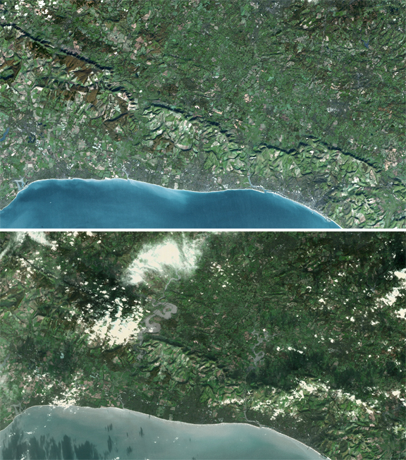
Top: Before the storms
Bottom: After the storms
Image credit DMC2, Image ©DMCii 2014, all rights reserved.
The River Adur on the right side of the image with flooding around Upper Beeding, and Steyning.
Brighton Pier is visible jutting into the sea at the far right side of the image.
The UK’s Environment Agency is using the satellite data received from Charter member agencies for calculation of flooded Agricultural Land and sites of special scientific interest (SSSI). More than 200 flood alerts were issued as of 06 January and more storms are forecast to bring further rain and coastal flooding along the south east and west of England over the coming days.
Use of satellite remote sensing data provided by the Charter is becoming more common in the UK, with three activations for flooding in winter 2012 and 2013, and one already in 2014. Prior to 2012, the last UK activation for flooding was in 2007. Rrest assured that, even as the UK dries out in the wake of the storm, satellites such as UK-DMC2 are keeping an unblinking watch over all.