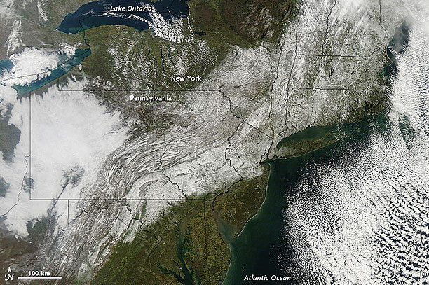
Nicknamed “Snowtober,” the storm left wet, heavy snow on trees still loaded with leaves. News reports described snapped branches, snapped power lines, and utility companies scrambling to restore lights and heat. The Moderate Resolution Imaging Spectroradiometer (MODIS) on NASA’s Terra satellite captured this natural-color image on October 30, 2011. A swath of snow sweeps from West Virginia northeastward to Maine. Clouds hover east and west of the snow, blocking the satellite sensor’s view of western Pennsylvania and parts of the Atlantic Ocean.

NASA image courtesy Jeff Schmaltz, MODIS Rapid Response Team, Goddard Space Flight Center. Caption by Michon Scott.
The storm broke snowfall-total records in cities throughout the U.S. Northeast, Capital Weather Gang reported. The nor’easter was also surprisingly intense, causing wind gusts along the Massachusetts coastline of 69 miles (111 kilometers) per hour. More than three million homes and businesses lacked electricity in the wake of the storm, according to news reports. Capital Weather Gang reported that this storm caused a record loss of electricity in Connecticut—worse than the power loss caused by Hurricane Irene. As residents headed back to work on October 31, closed or icy roads complicated commutes in multiple states. Fortunately, rising temperatures were expected to help melt the snow.

