
[Satnews] Panasonic Weather Solutions (Panasonic), a division within Panasonic Avionics Corporation, announces their 4DAero, an electronic flight bag (EFB) application.
This new solution provides pilots a user-friendly, interactive display of a planned flight route synchronized in time and space with highly accurate forecasted weather and other potential aviation hazards from the Panasonic 4D Weather platform. Panasonic Weather Solutions’ 4DAero is a proprietary weather forecasting application that gives pilots access to the industry’s most accurate weather forecast and makes it available in an EFB platform. It offers unprecedented situational awareness that optimizes strategic flight planning and real-time, in-flight tactical navigation decision-making. PWS announced the application at the 2015 National Business Aviation Association conference.
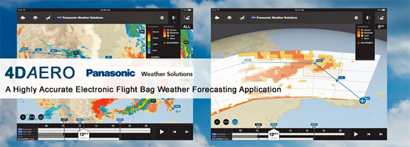
4DAero provides a global base map that includes an aircraft’s flight route with selectable graphical overlays that depict:
- Thunderstorms (Live Radar and Forecasted Storms)
- Turbulence (Reported and Forecasted)
- Detailed Winds Aloft (Surface through 45,000 ft.)
- Icing and icing potential
- Temperature
- Airport conditions
- Standard aviation weather products such as SIGMETS, TAFs, METARS
- Dynamically changing NOTAMs such as temporary flight restrictions (TFR), unplanned runway closures, and special activity airspace (SAA) activations
- Hazards such as lightning occurrences and wind shear advisories
A pilot using 4DAero can analyze potential changes to the route of flight graphically with drag and drop, as well as by editing waypoints. Based on forecasted weather and aviation flight warnings, pilots can adjust their route to avoid expected hazards or undesired conditions, both laterally and vertically, to create a safer and more efficient flight path.
The 4DAero display can be customized to include terrain features, navigation aids (NAVAIDS), airports, and flight information region (FIR) boundaries. 4DAero provides the most current en-route information available when connected via the Internet, including while airborne using Panasonic Global Communications Services, the industry leading satellite broadband service, and SmartSky 4G LTE, the next generation in Air-To-Ground broadband networks. Whether in-flight or on the ground, pilots can download the latest information affecting the planned route of flight and the surrounding area, including the latest weather forecasts.
Executive Comment
“4DAero is the best EFB solution for pilots who need to make fast and informed decisions in very critical situations. 4DAero will also significantly increase the efficiency of flight operations,” said Don DeBlasio, Executive Director of Panasonic Weather Solutions. “4DAero relies on the Panasonic 4D Weather platform, which includes our unique atmospheric datasets, which are collected in real time by hundreds of commercial aircraft in flight. It also includes our advanced 4D quality control and proprietary weather models. When combined, these services provide weather forecasts that consistently surpass the accuracy of other weather services—government or civilian.”
4DAero will be commercially available in Spring 2016, initially on the iOS platform.