
Credit: NASA/GOES Project — Text credit: Rob Gutro, NASA's Goddard Space Flight Center, Greenbelt, Md. and Hal Pierce, SSAI
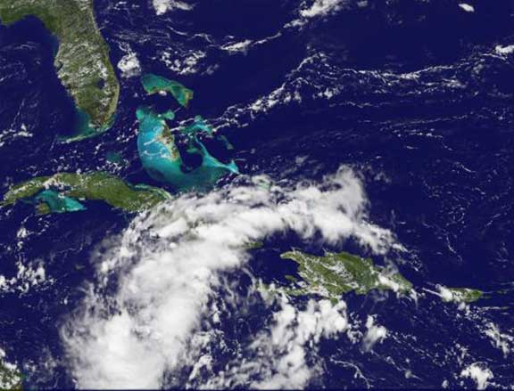
The showers and thunderstorms in System 92L are still poorly organized in this broad area of low pressure over the west-central Caribbean Sea. At 1:53 p.m. EDT on September 13, Montego Bay/Sangster Airport in Jamaica was reporting light rain and 8 mph winds from the east. At the Holguin Airport, Cuba, light rain and thunderstorms were reported with winds blowing from the east-southeast at 12 mph. The National Hurricane Center does note that there's a 40 percent chance that System 92L could develop into a tropical cyclone in the next 48 hours as it moves west-northwestward around 20 mph. Whether it becomes tropical depression 13 in the Atlantic Ocean basin or not, locally heavy rainfall is possible over portions of Hispaniola, Jamaica, Cuba, The Cayman Islands, and the Yucatan Peninsula during the next day or two. These heavy rains could cause life-threatening flash floods and mud slides, especially in areas of mountainous terrain.