
Surrey Satellite Technology Ltd. (SSTL) has released the first Synthetic Aperture Radar (SAR) images taken from orbit by NovaSAR-1, a technology demonstration mission launched into a 580 km. SSO on September 16, 2018.
The S-band SAR images were acquired using the satellite’s stripmap mode at 6 meter resolution and are 20 km. wide by 87 km. long. They were taken over Sydney Harbor and Cairo and can be viewed and downloaded at https://www.sstl.co.uk/novasar-images.
Mission partners signed up for capacity from NovaSAR-1 include the UK Space Agency, Australia’s Commonwealth Scientific and Industrial Research Organisation (CSIRO), and the Indian Space Research Organisation (ISRO).
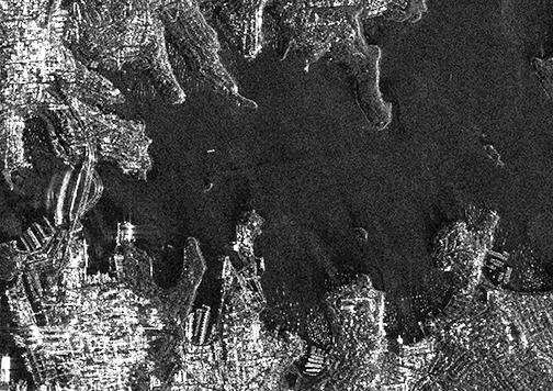
NovaSAR-1 image capture of Sydney Harbor. Image is courtesy of SSTL.
The image of Sydney to the right was taken at night and cropped images viewable at the above mentioned URL were taken from the original and show Sydney Harbor Bridge, Sydney Opera House, The Royal Botanic Garden, Bondi beach and several boats crossing the harbor.
A second close up from the original image available for viewing at the above listed URL shows small boats moored in the natural harbor at Church Point, north of Sydney in a demonstration of the usefulness of SAR for detecting vessels of many different sizes and types, particularly at night or through cloud cover.
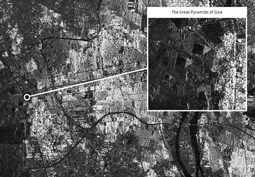
20 km by 87 km area at 6 meter resolution of Cairo, Egypt. Acquired by NovaSAR-1, November, 2018. Image is courtesy of SSTL.
The image of Cairo shows the River Nile flowing from Upper Egypt through Cairo and down towards Beni Suef. Urbanization, cultivation along the Nile, and the non-irrigated desert areas, are clearly distinguishable. Cropped images taken from the original show The Great Pyramids of Giza, and the Red Pyramid and Bent Pyramid near Dahshur.
Synthetic Aperture Radar is a powerful tool for monitoring the Earth from space due to its ability to see through clouds and image the Earth night and day. NovaSAR-1 is the world’s first commercial SAR satellite to be operated at a 10:30 equator crossing time, providing time diversity for radar observations by affording increased daylight imaging opportunities in addition to night acquisitions.

Artistic rendition of the NovaSAR-1 satellite.
Image is courtesy of SSTL.
NovaSAR-1 was designed and manufactured by SSTL, with an S-band SAR payload developed by Airbus Defence and Space in Portsmouth and an Automatic Identification Receiver supplied by Honeywell Aerospace. The SAR payload has a dedicated maritime mode designed with a very wide swath area of 400km to enable the monitoring of the marine environment, and will provide direct radar ship detection information simultaneously with AIS ship tracking data to assist with the identification and tracking of sea-going vessels.
In addition to operating in maritime mode, NovaSAR-1 has been optimized with three additional imaging modes, including a six meter resolution imaging mode, for a range of other applications such as flood monitoring and agricultural and forestry applications. The satellite has been designed to offer a high throughput of data, observing in a variety of polarization combinations to add additional information to acquisitions in the form of ‘color’.
NovaSAR-1 is operated on orbit from SSTL’s Spacecraft Operations Centre in Guildford, UK.
Executive Comments
Sam Gyimah, the UK’s Science and Education Minister, toured SSTL’s satellite assembly and operations facilities and viewed the new images from NovaSAR-1. The Minister said that, yet again, UK research and innovation is truly out of this world. This ‘eye in the sky’ can capture an image a dozen times wider than the Strait of Dover and the data it provides can help crack problems from illegal shipping to alerting the UK to damaging pollution that needs to be countered. This satellite, backed by a £21 million investment from the UK Government, is a great example of how the government is working with the space sector to remain at the forefront of pioneering science and exploration.
Andrew Cawthorne, Director of Earth Observation at SSTL, added that company has have worked closely with the SAR experts at Airbus in Portsmouth to develop NovaSAR-1 and the whole team is delighted with these first results — the outcome of space engineering expertise, ingenuity and collaboration. Over the coming weeks, SSTL spacecraft operators will continue to test the capabilities of the spacecraft as the satellite is tasked to image locations around the world, working toward the start of service delivery to mission partners in the near future.