
Over 8,000 boundary pillars at the Nepal-India border will institute an internationally accepted positioning system using Global Navigation Satellite, this according to a news report at the webindia123 infosite.
The third meeting of the Nepal-India Boundary Working Group (BWG) at surveyor general level, which concluded in Nepal on Saturday, decided to install the 8,553 border pillars with the Boundary Global Navigation Satellite System, read a statement that was issued by the Nepali government. The GPS system will help finding the location, longitude, height and all positioning of the pillars.
Nepal remains adamant that no map agreement with India will be signed until the Susta and Kalapani differences are resolved.
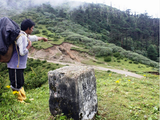
Nepal and India have erected a total of 8,553 pillars along the border, of which 1,325 are missing and 1,956 damaged. The Boundary Working Group is responsible for the construction, restoration and repair of border pillars, including the clearing of the no-man's land. The mechanism is not mandated to resolve a boundary row in Susta and Kalapani, the most disputed border areas between Nepal and India.
The Boundary Working Group reviewed reports submitted by the Survey Official Committee and Joint Field Survey Teams (FST). Nepal and India in 2014 agreed to settle the boundary row within three years in addition to Susta and Kalapani. Officials from both the sides have already prepared and agreed 182-sheet strip maps of the boundary through the GPS but have not signed the protocol due to Nepal's denial. The Nepali side said it will not sign the maps until the boundary row in Susta and Kalapani is resolved.
Two technical committees—SOC and FST—reports to the BWG about the repairing, maintenance and the upgrades to the pillars and encroachment on the no-man's land from both the sides. The meeting also finalized the target and schedule for the next field season and decided to prioritize the completion of the backlogged tasks from previous field seasons. Both the sides emphasized the importance of making local authorities and people living along the border aware of the field work being conducted by the joint teams, said the statement. Work on settling the boundary disputes was stalled after 2007, but strip maps were prepared, except for Kalapani and Susta.
During Prime Minister Narendra Modi's Nepal visit in 2014, the two sides agreed to expedite efforts to sort out the differences. Then Nepali Prime Minister Sushil Koirala and Modi agreed to direct their foreign secretaries to continue working on the issue of Kalapani and Sustna. However, there have been no substantial talks between the foreign secretaries. The Indian side has been pressing for early signing of the "agreed and initiated strip maps."
India says that talks on Susta and Kalapani could be continued after signing agreed upon documents. Nepal, however, maintains that all the issues should be resolved together.