
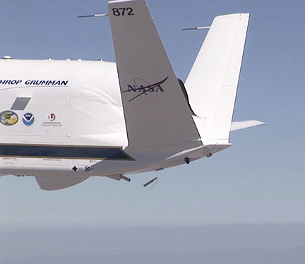
A NASA Global Hawk releasing a dropsonde. (Photo courtesy of NOAA/NASA)
A Northrop Grumman (NYSE:NOC)-produced Global Hawk high altitude unmanned aircraft began a series of flights over the Pacific Ocean on Feb. 11 as part of a campaign to study atmospheric rivers. Known as Winter Storms and Pacific Atmospheric Rivers (WISPAR), the research is being done by the National Oceanic and Atmospheric Administration (NOAA) to improve winter storm forecasts. The purpose of the WISPAR project is to collect data on how atmospheric rivers form and behave. Atmospheric rivers are narrow regions in the Earth's atmosphere that transport large amounts of water vapor. These atmospheric rivers could transport enough water vapor on any given day to lead to flooding in California, or contribute to a beneficial increase in the snowpack.
NOAA and the NASA Dryden Flight Research Center (DFRC) have partnered to install payloads on a NASA Global Hawk for the WISPAR campaign. The high-altitude long endurance (HALE) Global Hawk provides the optimal platform for environmental science missions because it can carry various scientific payloads up to 65,000 feet altitude for 30 hours to remote locations over the ocean. "Using a Global Hawk for scientific studies is a great testament to the versatility of the platform," said Richard Laboda, the Northrop Grumman Aerospace Systems NASA Global Hawk program manager. "To date, we have been able to successfully integrate varying types of scientific instruments onto the Global Hawk to support numerous missions and look forward to various ways the HALE unmanned aircraft systems will be used in supporting future scientific studies. Northrop Grumman contributes to the WISPAR campaign by providing maintenance and flight operations support as part our partnership with NASA," said Laboda.
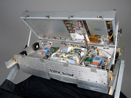
The High Altitude Monolithic Microwave Integrating Circuit Sounding Radiometer, or HAMSR, developed by NASA's Jet Propulsion Laboratory, is a remote-sensing instrument that was carried on NASA's Global Hawk during the WISPAR flights. (NASA Photo /Tony Landis)