
[SatNews] The Emirates Institution for Advanced Science and Technology (EIAST) has launched the Advanced Aerial Systems Program, which aims to develop UAE capabilities in the fields of designing, manufacturing and operating advanced aerial systems, in line with EIAST’s mission to develop advanced science and technology across the UAE.
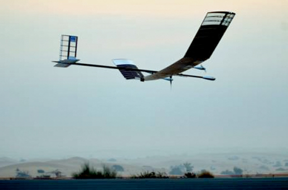
The inaugural flight of the EIAST HAPS UAS.
The first project in the program is the joint-development of the High Altitude Pseudo Satellite (HAPS) system in partnership with Airbus DS, one of the companies under the Airbus Group. The HAPS system is the world's leading High Altitude Pseudo-Satellite (HAPS), using only solar power to fly above the weather to provide persistent presence for a wide range of applications. Using highly advanced designs, materials and systems, HAPS has demonstrated the ability to fly for more than two weeks, ten times longer than any other Unmanned Aerial System (UAS). The system combines between the benefits of a satellite, in terms of altitude and applications, and an aircraft, in terms of re-usability and coverage.
The HAPS system can fly in the stratosphere at an altitude of 65,600 feet (20km) above air traffic, making it a robust system able to handle various applications. Due to its high flexibility, the payloads on the system can be changed on the ground to fit with many different applications. The targeted applications from this system include thermal imaging, full HD video imaging (1080p), creating temporary communication networks and strengthening navigation systems. The operational version of the aircraft is projected to go into operation by end of 2016.
In March of this year, a team of UAE engineers worked in collaboration with Airbus DS to prepare a demonstration model of the HAPS system to fly for the first time in Dubai. By August, the system was being assembled and tested in Dubai in preparation for a flight day in September. After assembly, integration and testing, the aircraft weighed just 34kg, with a wing-span of 18 meters, carrying a full HD Video payload. The aircraft is equipped with on board video technology and has an imaging resolution of approximately 10 cm, depending on altitude,, equipped with 30 times zooming capability.
The system was successfully launched on Thursday, September 11, 2014, at 6:31am from the Margham area of Dubai. The test flight lasted 23 hours and 47 minutes. Apart from the duration of the flight, the aircraft reached a record altitude of 61,500 feet (18km) before successfully landing back in Dubai on Friday, September 12, 2014, at 6:18 a.m. This is now highest recorded altitude for any flight in the region.
_2.jpg)
Photo of the launch of an Airbus Defense and Space (DS) Zephyr HAPS.
Image courtesy of Airbus DS.
The second phase, which will be completed in 2016, will see UAE engineers joining forces with the Airbus DS team in developing the first generation of the HAPS system. EIAST will design and manufacture parts of the next generation system in Dubai, with the help of Airbus DS
H.E. Yousuf Hamad Al Shaibani, Director General of EIAST, said: “This project represents a milestone for EIAST and is a new achievement that will support our efforts to create a culture of applied research and development driven by advanced technologies and innovation. We recognize the value of developing a world-class technical platform, which falls in line with achieving the UAE’s Vision 2021 of a competitive Knowledge Economy. Our programs at EIAST aim to provide engineering capabilities in the design, development and operation of different aerial and space systems that will enhance UAE’s global standing”.
.jpg)
Airbus Defense and Space Zephyr HAPS in flight.
Photo courtesy of Airbus DS.
Many local authorities took part in the first phase of the project, including Dubai Civil Aviation Authority, which coordinated with all the airspace stakeholders across the UAE to meet the project’s airspace requirement without affecting civil air traffic. This was demonstrated by the successful test flight of HAPS in the world’s busiest airspace. Furthermore, the Office of His Highness the Crown Prince of Dubai provided various forms of support including providing the facilities setup to house the system. Skydive Dubai also supported in providing the location and runway for the flight trail. Dubai Air Navigation Services collaborated with EIAST during the project by providing navigation services and weather forecast that ensured the safe planning of the flight path.
EIAST was established by the Dubai Government in 2006 with the goal of promoting a culture of advanced scientific research and technology innovation in Dubai and the UAE, and enhancing technology innovation and scientific skills among UAE Nationals. It is mainly involved in outer space research and development, satellite manufacturing and systems development, space imaging, and ground station services and support for other satellites.
The EIAST infosite may be reached at http://eiast.ae/