

The twin Sentinel-1 satellites have—for the first time—combined to show their capability for revealing even small deformations in Earth’s surface.
Following its orbital maneuvers, the recently launched Sentinel-1B satellite reached its designated orbit position on June 15th. The satellite is now orbiting Earth 180 degrees apart from its twin, Sentinel-1A, at an altitude of almost 700 km. With both satellites finally in the same orbit, together they can cover the entire globe every six days.
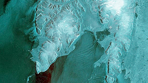
Sentinel-1B’s first data strip stretches 600 km from 80°N degrees through the Barents Sea. The image, which shows the Norwegian Svalbard archipelago on the left, was captured on 28 April 2016 at 05:37 GMT (07:37 CEST) – just two hours after the satellite’s radar was switched on.
Contains modified Copernicus Sentinel data [2016], processed by ESA.
The two-satellite ‘radar vision’ mission for Europe’s Copernicus program carries an advanced radar to provide an all-weather, day-and-night supply of imagery of Earth’s surface. It has now been demonstrated that future images acquired by the pair can be merged to detect slight changes occurring between scans. This technique is particularly useful for generating accurate maps of surface deformation over wide areas, such as those caused by tectonic processes, volcanic activities or landslides and is also an ideal tool for monitoring glacier flow and changes in Arctic and Antarctic ice shelves.
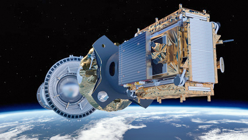
The Sentinel-1B satellite in orbit.
Sentinel-1’s first such paired ‘interferogram’ combined a Sentinel-1A scan over southern Romania on June 9th with a Sentinel-1B acquisition over the same area just one day before reaching its target orbit position. Another interferogram over northwest Romania was produced shortly after Sentinel-1B reached final orbit. The rainbow-colored patterns are related to topography and they demonstrate that the two satellites’ identical radars are accurately synchronized, pointing in the same direction and that the satellites are in their correct orbits.
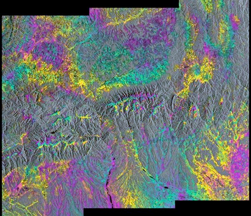
This ‘interferogram’ combines a Sentinel-1A radar scan from June 9, 2016, over southern Romania with a Sentinel-1B acquisition from 15 June over the same area – shortly before Sentinel-1B reached its designated orbit. Bucharest is near the lower right corner of the image. The color pattern is related to local terrain topography.
Contains modified Copernicus Sentinel data (2016)/ESA/Norut
Once commissioning is completed in mid-September, the pair will be ready to deliver data for the systematic and routine monitoring of Earth surface deformation and ice dynamics.
“After the great success of generating the first radar image less than three days after liftoff, I am very happy to report another outstanding success as it is the generation of the first interferograms with Sentinel-1B on the same day that we reached the orbital position, 180 degrees apart from Sentinel-1A,” said ESA’s Sentinel-1 project manager, Ramón Torres. “It is of paramount importance to the mission that we have demonstrated, at the first try, that the two Sentinel-1 satellites work very well together.”