
[SatNews] October 2014 marks the five-year anniversary for two sensors that the U.S. Naval Research Laboratory (NRL) has been operating aboard the International Space Station (ISS).
The Hyperspectral Imager for the Coastal Ocean (HICO) takes images of oceans in many different wavelengths to help scientists see what’s in the water, be it sediment or chlorophyll or runoff. The Remote Atmospheric and Ionospheric Detection System (RAIDS) also measures light in various wavelengths, but looking at the upper atmosphere and ionosphere.
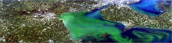
The Hyperspectral Imager for the Coastal Ocean (HICO) took this image of Lake Erie, Ohio on September 3, 2011. Dr. Mary Kappus, the U.S. Naval Research Laboratory lead, said, “Hyperspectral means it takes a picture, but for each spot it separates the light into over 100 separate wavelengths.”
Photo provided by U.S. Naval Research Laboratory.
HICO-RAIDS launched to the ISS as one payload in 2009. Once docked, Dr. Scott Budzien, the Principal Investigator for RAIDS, says, “They took us out and attached us to the ‘porch’ of the Japanese Experiment Module.” He adds, “We have the distinction of being the first U.S. payload that was attached [there].”
HICO and RAIDS were both designed as one-year missions.
“Just about a week ago we fired up our UV [ultraviolet] instrument again and we’re collecting data as we speak. So, still chugging along—an Energizer Bunny,” said Budzien
For the first three years, HICO operated with funding from the Office of Naval Research (ONR). NRL partnered with Oregon State University to host a website for the images and to field proposals from outside scientists who want to task HICO to capture certain images. Today, the National Aeronautics and Space Administration (NASA) sustains HICO. “Now the data also goes to NASA’s ocean color website, where they’ve had open ocean data for years,” says Dr. Mary Kappus, who leads HICO. As of the five-year anniversary, HICO has collected nearly 10,000 images.
Kappus added, “HICO’s definitely been a really successful transition. It shows the synergy between NASA and NRL and academia. There’s a lot of overlap in the things we need to understand about the ocean. If you work together to do some of these things, you can get a lot of information and share it commonly.”
HICO-RAIDS was integrated and flown under the direction of the Department of Defense Space Test Program. RAIDS was built jointly by NRL and The Aerospace Corporation, with additional support from the Office of Naval Research.
Above 100km, RAIDS gets global temperatures based on infrared
RAIDS accurately measures very fine changes in shades of color from the Earth’s airglow. “RAIDS is a suite of eight different spectrographs, spectrometers, and photometers,” says Budzien. “We cover a really wide wavelength range—from 50 nanometers in the extreme ultraviolet, all the way out to the near infrared—so we have this unusual, very broad spectral coverage.”
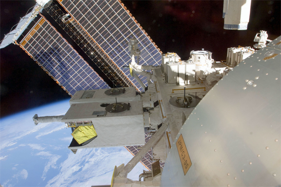
Two U.S. Naval Research Laboratory (NRL) sensors, known as HICO-RAIDS, have been docked on the International Space Station for five years. “We have the distinction of being the first U.S. payload that was attached [there],” says Dr. Scott Budzien, the lead NRL scientist for RAIDS. “We were strongly focused on understanding the temperature of the atmosphere between about 100 km above the surface up to about 150 km above the surface.”
Photo provided by NASA.
Two U.S. Naval Research Laboratory (NRL) sensors, known as HICO-RAIDS, have been docked on the International Space Station for five years. "We have the distinction of being the first U.S. payload that was attached [there]," says Dr. Scott Budzien, the lead NRL scientist for RAIDS. "We were strongly focused on understanding the temperature of the atmosphere between about 100 km above the surface up to about 150 km above the surface." (Photo provided by NASA/Released)
Two U.S. Naval Research Laboratory (NRL) sensors, known as HICO-RAIDS, have been docked on the International Space Station for five years. “We have the distinction of being the first U.S. payload that was attached [there],” says Dr. Scott Budzien, the lead NRL scientist for RAIDS. “We were strongly focused on understanding the temperature of the atmosphere between about 100 km above the surface up to about 150 km above the surface.” (Photo provided by NASA/Released)
The instrument scans the atmosphere up and down—or, it did. “We scanned from basically the space station altitude all the way to the Earth’s surface, looking down below the horizon.”
Then, in December 2010, the scan drive electrically malfunctioned and RAIDS got stuck “pointed down on the atmosphere looking at a slant.” (Electrical malfunctions aren’t unusual for hardware operating in the harsh environment of space.) Even so, Budzien says, “It was a one year mission, and the scan platform worked for 15 months, so we were pleased with that.”
While RAIDS was fully operational, it led to three important scientific discoveries.
First, “We were strongly focused on understanding the temperature of the atmosphere between about 100 kilometers (km) [60 miles] above the surface up to about 150 km [90 miles] above the surface,” says Budzien. “That’s a really difficult altitude range to measure.” By targeting near-infrared wavelengths, Budzien’s team—and partners at The Aerospace Corporation in El Segundo, California—”produced some of the first global measurements of temperature through that altitude range.”
NRL’s breakthrough came from understanding the processes that affect the different energy levels of oxygen molecules as they collide and temperature. “There are many different energy levels in the oxygen molecule,” says Budzien. “Depending on temperature and how these molecules are getting knocked around, that affects the population of the energy states, and so the spectrum changes shape.”
“Depending on the fine shade of color at the near infrared wavelengths, we can figure out what the temperature is.”
The second discovery had to do with measuring the electron density of the ionosphere. Dr. Andrew Stephan, an NRL scientist also on the project, “devised a technique by looking at two different extreme ultraviolet bands to make a more precise measurement of the daytime ionosphere.” He and partners at Boston University validated the technique against ground-based radar.
Finally, scientists at Virginia Polytechnic Institute and the New Mexico Institute of Mining and Technology used RAIDS to study nitric oxide (NO). “It’s a thermally important molecule high up in the atmosphere,” says Budzien. “They’re trying to understand how the chemistry of nitric oxide changes through the course of the day and night, and so they used RAIDS data to help refine their model.”
While RAIDS now collects much less scientific data, it’s still useful for understanding how these types of instruments hold up in space. As an example, Budzien’s team learned that RAIDS’ sensitive optical sensors still perform well aboard the ISS.
“People were afraid that because of the manned presence and vehicles that come and go all the time, that the environment would be too dirty to collect extreme ultraviolet science data as we do,” he says. “So our experiment contributes to lifetime studies for sensors on the ISS.”
But Budzien hasn’t given up yet on repairing RAIDS. He’s proposed to build a jack that one of the robotic arms already on ISS could use to “point [RAIDS] at a new altitude that would be more scientifically interesting. And then we could collect more data and do world class science all over again.”
HICO reads chlorophyll, sediment in coastal oceans
When light shines through water, it reflects and absorbs differently depending on what else is in the water. Says Kappus, “If there’s a lot of chlorophyll it’ll absorb at certain wavelengths, if it’s very clear it won’t absorb at those wavelengths, and so forth. If there’s a lot of sediment, it’ll scatter more at some of the redder wavelengths, which is what makes the water look brown.”
HICO (pronounced “HIGH-co”) captures these variations in light and color with spectra for each point in a picture. Explains Kappus, “Hyperspectral means it takes a picture, but for each spot it separates the light into over 100 separate wavelengths.” While more detailed than necessary for open ocean, which Kappus describes as mostly blue, the coast is more complicated.
“You’ve got runoff from rivers, you got more turbulence, you’ve got more organic things in the water, and more sediments in the water—and it changes on smaller spatial scales,” she says.
Every day, NRL sends up commands tasking HICO where to take pictures. “We can only take one image on each orbit,” says Kappus, “which gives you about 15 a day maximum.” Some of the tasking supports other NRL projects, NASA sometimes tasks for pictures from a natural disaster area, and many of the tasks come from academia.
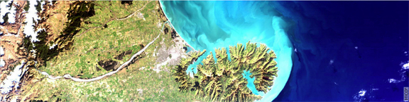
The Hyperspectral Imager for the Coastal Ocean (HICO) took this image of Christchurch, New Zealand on August 7, 2011. “HICO’s definitely been a really successful transition,” says Dr. Mary Kappus, the U.S. Naval Research Laboratory (NRL) lead. “There’s a lot of overlap in the things we need to understand about the ocean.”
Photo provided by the U.S. Naval Research Laboratory.
“[HICO's] on the space station, which orbits in a strange orbit,” says Kappus. “You’re at different places, different times—sometimes they’re at angles that are not what you would sensibly choose for imaging.” NRL looks at how ISS will orbit in the coming week, and “puts out the list of all the opportunities for the coming week, and people say, ‘Oh I want that that that that.’ And then we have a teleconference once a week to deconflict.”
Kappus mentions some of the science HICO’s supported, including measuring water flow or velocities remotely. “We have a good [algorithm] in our branch, and so they used HICO data to study a really large area, the whole English channel.” Another NRL scientist worked with colleagues in Russia to measure run-off in the Sea of Azov.
Additionally, she says, “We’ve done a lot of stuff actually just understanding the sensor and signal-to-noise characteristics and changes to radiometric calibration—so really more technical, esoteric things.” She describes remote sensing as a cycle: “We’re interested in the exploitation of the data, but we’re also interested in improving the next sensor.”
Kappus is delighted that, given all the design trade-offs the team made to get HICO built quickly and cheaply (not using space-hardened hardware, for example), that it’s still such a good program. “It’s a great team, not a very big team, which is what works,” she says. “Maybe not a lot of money, not a lot of time. You focus, you work hard, and get stuff out.”