
NASA image courtesy MODIS Rapid Response Team at NASA GSFC. Caption by Michon Scott.
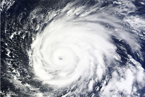
The Moderate Resolution Imaging Spectroradiometer (MODIS) on NASA’s Terra satellite captured this natural-color image of Hurricane Igor at 10:15 a.m. AST (14:15 UTC) on September 14, 2010. As it did the day before, the storm shows the characteristics of a powerful hurricane — spiral arms stretching across hundreds of kilometers, and a distinct eye. On September 14, Igor was traveling slowly toward the west-northwest. The NHC warned of swells from the storm affecting the Leeward Islands and Puerto Rico over the next couple days, although no coastal watches or warnings were in effect. The same day that MODIS acquired this image, observations by the Atmospheric Infrared Sounder (AIRS) instrument on NASA’s Aqua satellite detected a 170-degree difference between the frigid cloud tops of Hurricane Igor and the warm sea surface below, which fueled the powerful storm.