[SatNews] For years, airborne law enforcement teams wrestled with synchronizing the images on their video screens with coordinates on paper maps as they directed the movements of ground units below them.
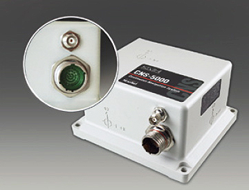
Now a breakthrough advance in real-time video tracking technology is offering a better way. Called the Augmented Reality System (ARS), this dynamic real-time mapping system gives airborne law enforcement teams the ability to overlay street maps and other data on live video with a touch of a computer screen, making coordination with ground units more effective and efficient. However, for ARS to function aboard dynamic platforms like helicopters, ARS developers Churchill Navigation and Paravion Technology, Inc., required a precision position and navigation system immune to vibration and lightweight enough for airborne use. They found the solution in the CNS-5000 inertial navigation system from KVH Industries, Inc., (Nasdaq: KVHI). KVH’s CNS-5000 provides the navigation and position data needed by the dynamic mapping software at the heart of the high-tech video system.
For its participation in development and willingness to test the system, the Denver Police Department’s air support unit received one of the first fully functional versions of the system, which it uses every day. The DPD has also been instrumental in getting the system approved by various U.S. federal agencies and has taken prospective customers on flights to test the new technology. According to Churchill, numerous agencies have already written the ARS into their budgets while a handful of others are seriously considering this valuable new product. KVH’s fiber optic guidance and sensor systems are used in an array of commercial and defense-related stabilization, navigation, autonomous vehicle, and precision guidance applications.