
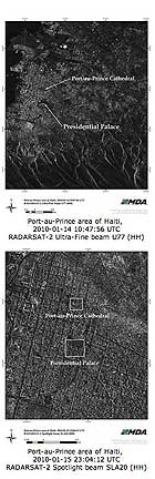
When a natural disaster of the magnitude experienced in Haiti occurs, there is an urgent need to identify major changes on the ground. Satellite imagery acquired immediately after the event provides updated views of how the landscape has changed and the extent of damage to critical infrastructure such as buildings, roads, and airports. These images can be compared with satellite imagery taken before the event to help identify areas that have been hit hardest by the disaster, determine passable routes for aid workers, as well as safe areas suitable for establishing aid camps to provide medical support and shelter.
Launched in 2007, RADARSAT-2 is an advanced commercial C-band Synthetic Aperture Radar satellite that offers new imaging capabilities and a faster turn-around schedule for data acquisition and product delivery. It provides enhanced information for applications such as environmental monitoring, ice mapping, resource mapping, disaster management, and marine surveillance. RADARSAT-2’s ability to collect imagery independent of darkness or inclement atmospheric conditions is a valuable support during times of emergency to supplement airborne and ground resources for local and regional damage assessment.