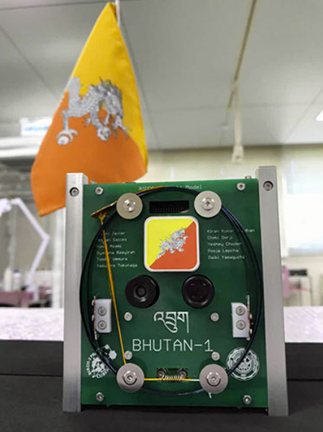
Photo of the Bhutan-1 smallsat.
Bhutan's first cubesat — BHUTAN-1 — is ready for delivery to the Japanese Aerospace Exploration Agency (JAXA) for launch — cubesat Flight Model (FM) delivery was recently organized by Japan's Kyushu Institute of Technology (Kyutech).

The cubesat, weighing less than 1.5 kgs., will be delivered to JAXA this April. Bhutan, along with Malaysia and the Philippines, is currently participating in the second joint global multi-nations BIRDS Project called BIRDS-2, initiated by Kyutech, represented by four engineers from the telecom and space division of the information and communications ministry (MoIC).
MoIC secretary Dasho Karma W Penjor said, this marks Bhutan’s first step towards development of Bhutan’s Space Science and Technology Program, a vision of His Majesty The King, noting that the project was started in late 2016 as a manifestation of His Majesty The King’s vision for Bhutan’s foray into space science and technology and for Bhutan to make a preliminary entry along with members of the international community into space. He added that space science and technology has the potential to leapfrog socioeconomic development and especially so for a country like Bhutan with a dispersed population and a harsh and physically challenging geographic environment.
Under the BIRDS-2 Project that began in November 2016, engineers along with participants from the Philippines and Malaysia will build three 1U cubesats.
With the finalization of the missions by December 2016, the team began building and testing the design, completing those tasks in March of last year. After verifying the functions of each subsystem, the team built the first Engineering Model (EM-1) of the satellite in June. By October, the EM-2 was completed and works on developing the Flight Module (FM) began.
Once launched, the satellite will operate in a low altitude of about 500 to 1,500 km. With the help of two high-end cameras, the satellite will capture high quality photographs of the country, with the imagery being used to help examine the conditions of the glaciers, lakes, forest covers and provide basic communication services.
Article source: Kuenseline, Tshering Palden

